Huarina
You can help expand this article with text translated from the corresponding article in German. (February 2010) Click [show] for important translation instructions.
- View a machine-translated version of the German article.
- Machine translation, like DeepL or Google Translate, is a useful starting point for translations, but translators must revise errors as necessary and confirm that the translation is accurate, rather than simply copy-pasting machine-translated text into the English Wikipedia.
- Do not translate text that appears unreliable or low-quality. If possible, verify the text with references provided in the foreign-language article.
- You must provide copyright attribution in the edit summary accompanying your translation by providing an interlanguage link to the source of your translation. A model attribution edit summary is
Content in this edit is translated from the existing German Wikipedia article at [[:de:Huarina]]; see its history for attribution. - You may also add the template
{{Translated|de|Huarina}}to the talk page. - For more guidance, see Wikipedia:Translation.
Town in La Paz Department, Bolivia
Huarina Warina | |
|---|---|
Town | |
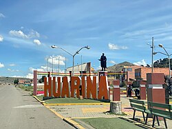 Main square views from Bolivia's National Route 2 | |
| 16°12′S 68°38′W / 16.200°S 68.633°W / -16.200; -68.633 | |
| Country |  Bolivia Bolivia |
| Department | La Paz Department |
| Province | Omasuyos Province |
| Municipality | Huarina Municipality |
| Population (2001) | |
| • Total | 1,308 |
| • Ethnicities | Aymara |
| Time zone | UTC-4 (BOT) |
Huarina is a location in the La Paz Department in Bolivia. It is the seat of the Huarina Municipality,[1][2] one of the four municipalities of the Omasuyos Province. President of Peru Andrés de Santa Cruz was born here.
Climate
| Climate data for Huarina (Huarina Cota Cota), elevation 3,838 m (12,592 ft), (1972–2011) | |||||||||||||
|---|---|---|---|---|---|---|---|---|---|---|---|---|---|
| Month | Jan | Feb | Mar | Apr | May | Jun | Jul | Aug | Sep | Oct | Nov | Dec | Year |
| Mean daily maximum °C (°F) | 14.9 (58.8) | 15.1 (59.2) | 15.3 (59.5) | 15.5 (59.9) | 15.2 (59.4) | 14.2 (57.6) | 14.1 (57.4) | 15.0 (59.0) | 15.7 (60.3) | 16.5 (61.7) | 16.7 (62.1) | 16.1 (61.0) | 15.4 (59.7) |
| Daily mean °C (°F) | 9.6 (49.3) | 9.6 (49.3) | 9.4 (48.9) | 8.4 (47.1) | 6.4 (43.5) | 4.9 (40.8) | 4.6 (40.3) | 5.8 (42.4) | 7.3 (45.1) | 8.8 (47.8) | 9.5 (49.1) | 9.8 (49.6) | 7.8 (46.1) |
| Mean daily minimum °C (°F) | 4.3 (39.7) | 4.0 (39.2) | 3.5 (38.3) | 1.4 (34.5) | −2.4 (27.7) | −4.3 (24.3) | −5.0 (23.0) | −3.5 (25.7) | −1.1 (30.0) | 1.0 (33.8) | 2.4 (36.3) | 3.4 (38.1) | 0.3 (32.6) |
| Average precipitation mm (inches) | 137.0 (5.39) | 88.9 (3.50) | 88.4 (3.48) | 36.0 (1.42) | 11.1 (0.44) | 9.4 (0.37) | 6.5 (0.26) | 13.6 (0.54) | 21.3 (0.84) | 41.4 (1.63) | 51.9 (2.04) | 90.9 (3.58) | 596.4 (23.49) |
| Average precipitation days | 18.1 | 13.8 | 12.6 | 6.8 | 2.5 | 1.6 | 1.7 | 2.6 | 4.5 | 7.0 | 7.7 | 12.0 | 90.9 |
| Average relative humidity (%) | 74.7 | 74.9 | 74.4 | 69.5 | 57.8 | 57.8 | 56.8 | 56.2 | 59.4 | 61.8 | 64.4 | 69.8 | 64.8 |
| Source: Servicio Nacional de Meteorología e Hidrología de Bolivia[3][4] | |||||||||||||
| Climate data for Huarina (Copancara), elevation 3,814 m (12,513 ft), (1990–2011) | |||||||||||||
|---|---|---|---|---|---|---|---|---|---|---|---|---|---|
| Month | Jan | Feb | Mar | Apr | May | Jun | Jul | Aug | Sep | Oct | Nov | Dec | Year |
| Mean daily maximum °C (°F) | 15.6 (60.1) | 15.7 (60.3) | 15.8 (60.4) | 16.2 (61.2) | 15.6 (60.1) | 15.5 (59.9) | 15.1 (59.2) | 15.4 (59.7) | 15.8 (60.4) | 16.2 (61.2) | 16.6 (61.9) | 16.3 (61.3) | 15.8 (60.5) |
| Daily mean °C (°F) | 9.9 (49.8) | 9.7 (49.5) | 9.5 (49.1) | 8.8 (47.8) | 6.4 (43.5) | 5.4 (41.7) | 5.2 (41.4) | 6.3 (43.3) | 7.9 (46.2) | 9.1 (48.4) | 9.7 (49.5) | 10.1 (50.2) | 8.2 (46.7) |
| Mean daily minimum °C (°F) | 4.3 (39.7) | 3.8 (38.8) | 3.2 (37.8) | 1.5 (34.7) | −3.4 (25.9) | −4.7 (23.5) | −4.6 (23.7) | −2.8 (27.0) | 0.1 (32.2) | 2.0 (35.6) | 2.7 (36.9) | 3.9 (39.0) | 0.5 (32.9) |
| Average precipitation mm (inches) | 136.6 (5.38) | 91.4 (3.60) | 73.1 (2.88) | 15.8 (0.62) | 5.8 (0.23) | 5.5 (0.22) | 3.9 (0.15) | 11.8 (0.46) | 13.8 (0.54) | 28.2 (1.11) | 38.9 (1.53) | 55.0 (2.17) | 479.8 (18.89) |
| Average precipitation days | 14.9 | 11.0 | 9.7 | 2.4 | 1.0 | 1.0 | 0.7 | 1.7 | 2.3 | 3.6 | 5.1 | 7.6 | 61 |
| Average relative humidity (%) | 72.7 | 70.6 | 67.8 | 62.2 | 56.1 | 58.4 | 56.5 | 59.8 | 59.0 | 59.8 | 64.7 | 67.6 | 62.9 |
| Source: Servicio Nacional de Meteorología e Hidrología de Bolivia[5][6] | |||||||||||||
References
- ^ www.bolivia.com (Spanish)
- ^ www.planguarani.com Archived 2011-07-15 at the Wayback Machine (Spanish)
- ^ "Base de datos Sistema Meteorológico–SISMET" (in Spanish). Servicio Nacional de Meteorología e Hidrología de Bolivia. Archived from the original on 7 June 2018. Retrieved 12 June 2024.
- ^ "índices climáticos para 149 estaciones meteorológicas en Bolivia" (in Spanish). Servicio Nacional de Meteorología e Hidrología de Bolivia. Retrieved 12 June 2024.
External links
- Gobierno Autónomo Municipal de Huarina – Official site
- v
- t
- e


Capital: La Paz

(and seats)
- Achacachi (Achacachi)
- Achocalla (Achocalla)
- Alto Beni (Caserío Nueve)
- Ancoraimes (Ancoraimes)
- Apolo (Apolo)
- Aucapata (Aucapata)
- Ayata (Ayata)
- Ayo Ayo (Ayo Ayo)
- Batallas (Batallas)
- Cairoma (Cairoma)
- Cajuata (Cajuata)
- Calacoto (Calacoto)
- Calamarca (Calamarca)
- Caquiaviri (Caquiaviri)
- Caranavi (Caranavi)
- Catacora (Catacora)
- Chacarilla (Chacarilla)
- Charaña (Charaña)
- Chulumani (Chulumani)
- Chuma (Chuma)
- Collana (Collana)
- Colquencha (Colquencha)
- Colquiri (Colquiri)
- Comanche (Comanche)
- Combaya (Combaya)
- Copacabana (Copacabana)
- Coripata (Coripata)
- Coro Coro (Coro Coro)
- Coroico (Coroico)
- Curva (Curva)
- Desaguadero (Desaguadero)
- El Alto (El Alto)
- Escoma (Escoma)
- General Juan José Pérez (Charazani)
- Guanay (Guanay)
- Guaqui (Guaqui)
- Huarina (Huarina)
- Ichoca (Ichoca)
- Inquisivi (Inquisivi)
- Irupana (Irupana)
- Ixiamas (Ixiamas)
- Jesús de Machaca (Jesús de Machaca)
- La Asunta (La Asunta)
- La Paz (La Paz)
- Laja (Laja)
- Licoma Pampa (Licoma)
- Luribay (Luribay)
- Malla (Malla)
- Mapiri (Mapiri)
- Mecapaca (Mecapaca)
- Mocomoco (Mocomoco)
- Nazacara de Pacajes (Nazacara)
- Palca (Palca)
- Palos Blancos (Palos Blancos)
- Papel Pampa (Papel Pampa)
- Patacamaya (Patacamaya)
- Pelechuco (Pelechuco)
- Pucarani (Pucarani)
- Puerto Acosta (Puerto Acosta)
- Puerto Carabuco (Puerto Carabuco)
- Puerto Pérez (Puerto Perez)
- Quiabaya (Quiabaya)
- Quime (Quime)
- San Andrés de Machaca (San Andrés de Machaca)
- San Buenaventura (San Buenaventura)
- San Pedro de Curahuara (San Pedro de Curahuara de Carangas)
- San Pedro de Tiquina (San Pedro de Tiquina)
- Santiago de Callapa (Callapa)
- Santiago de Huata (Santiago de Huata)
- Santiago de Machaca (Santiago de Machaca)
- Sapahaqui (Sapahaqui)
- Sica Sica (Sica Sica)
- Sorata (Sorata)
- Tacacoma (Tacacoma)
- Taraco (Taraco)
- Teoponte (Teoponte)
- Tiwanaku (Tiwanaku)
- Tipuani (Tipuani)
- Tito Yupanqui (Tito Yupanqui)
- Umala (Umala)
- Umanata (Umanata)
- Viacha (Viacha)
- Waldo Ballivián (Tumarapi)
- Yaco (Yaco)
- Yanacachi (Yanacachi)
- Anallajsi
- Ancohuma
- Chacaltaya
- Chachakumani
- Chawpi Urqu
- Ch'iyar Juqhu
- Illampu
- Illimani
- Jach'a Khunu Qullu
- Jach'a Waracha
- Janq'u Qullu
- Kunturiri (Los Andes)
- Kunturiri (Bolivia-Chile)
- Layqa Qullu
- Machu Such'i Qhuchi
- Mururata
- Phaq'u Kiwuta
- Qalsata
- Sirk'i Qullu
- Uma Jalanta
- Wayna Khunu Qullu
- Wayna Potosí
- Wila Lluxi
- Wiluyu Janq'u Uma
Authority control databases | |
|---|---|
| International |
|
| National |
|
 | This La Paz Department geography article is a stub. You can help Wikipedia by expanding it. |
- v
- t
- e


