Heide-Land
You can help expand this article with text translated from the corresponding article in German. Click [show] for important translation instructions.
- Machine translation, like DeepL or Google Translate, is a useful starting point for translations, but translators must revise errors as necessary and confirm that the translation is accurate, rather than simply copy-pasting machine-translated text into the English Wikipedia.
- Do not translate text that appears unreliable or low-quality. If possible, verify the text with references provided in the foreign-language article.
- You must provide copyright attribution in the edit summary accompanying your translation by providing an interlanguage link to the source of your translation. A model attribution edit summary is
Content in this edit is translated from the existing German Wikipedia article at [[:de:Amt Kirchspielslandgemeinde Heide-Land]]; see its history for attribution. - You may also add the template
{{Translated|de|Amt Kirchspielslandgemeinde Heide-Land}}to the talk page. - For more guidance, see Wikipedia:Translation.
Former amt in Germany

Flag
Coat of arms
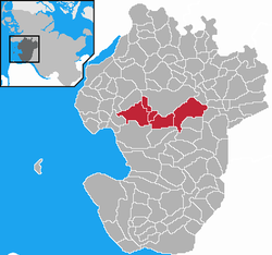
Map of Dithmarschen highlighting Heide-Land
Kirchspielslandgemeinde Heide-Land was an Amt ("collective municipality") in the district of Dithmarschen, in Schleswig-Holstein, Germany. It was situated around Heide, which was the seat of the Amt, but not part of it. In January 2008, it was merged with the Amt Kirchspielslandgemeinde Weddingstedt and the municipality Norderwöhrden to form the Amt Kirchspielslandgemeinde Heider Umland.
The Amt Kirchspielslandgemeinde Heide-Land consisted of the following municipalities (with population in 2005):
- Hemmingstedt (2.989)
- Lieth (396)
- Lohe-Rickelshof (1.942)
- Nordhastedt (2.753)
- Wöhrden (1.334)
- v
- t
- e
 Collective municipalities of Schleswig-Holstein in Germany
The Ämter are listed per district (Kreis)
- Berkenthin
- Breitenfelde
- Büchen
- Hohe Elbgeest
- Lauenburgische Seen
- Lütau
- Sandesneben-Nusse
- Schwarzenbek-Land
- Eiderstedt
- Föhr-Amrum
- Landschaft Sylt
- Mittleres Nordfriesland
- Nordsee-Treene
- Pellworm
- Südtondern
- Viöl
- Großer Plöner See
- Lensahn
- Oldenburg-Land
- Ostholstein-Mitte
- Bokhorst-Wankendorf
- Großer Plöner See
- Lütjenburg
- Preetz-Land
- Probstei
- Schrevenborn
- Selent/Schlesen
- Achterwehr
- Bordesholm
- Dänischenhagen
- Dänischer Wohld
- Eiderkanal
- Eidertal
- Fockbek
- Hohner Harde
- Hüttener Berge
- Jevenstedt
- Mittelholstein
- Nortorfer Land
- Schlei-Ostsee
- Arensharde
- Eggebek
- Geltinger Bucht
- Haddeby
- Hürup
- Kappeln-Land
- Kropp-Stapelholm
- Langballig
- Mittelangeln
- Oeversee
- Schafflund
- Südangeln
- Süderbrarup
- Auenland Südholstein
- Bad Bramstedt-Land
- Boostedt-Rickling
- Bornhöved
- Itzstedt
- Kisdorf
- Leezen
- Trave-Land
- Breitenburg
- Horst-Herzhorn
- Itzehoe-Land
- Kellinghusen
- Krempermarsch
- Schenefeld
- Wilstermarsch
- Bad Oldesloe-Land
- Bargteheide-Land
- Itzstedt
- Nordstormarn
- Siek
- Trittau
 | This Dithmarschen location article is a stub. You can help Wikipedia by expanding it. |
- v
- t
- e
54°09′N 9°04′E / 54.150°N 9.067°E / 54.150; 9.067


