Grade I and II* listed buildings in the London Borough of Redbridge
Map all coordinates using OpenStreetMap
Download coordinates as:
- KML
- GPX (all coordinates)
- GPX (primary coordinates)
- GPX (secondary coordinates)
There are over 9,000 Grade I listed buildings and 20,000 Grade II* listed buildings in England. This page is a list of these buildings in the London Borough of Redbridge.
Grade I
| Name | Location | Type | Completed [note 1] | Date designated | Grid ref.[note 2] Geo-coordinates | Entry number [note 3] | Image |
|---|---|---|---|---|---|---|---|
| Church of St Mary | Wanstead | Church | 1790 | 20 December 1954 | TQ4095787784 51°34′17″N 0°01′57″E / 51.571312°N 0.032526°E / 51.571312; 0.032526 (Church of St Mary) | 1081008 | 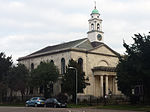 More images |
Grade II*
| Name | Location | Type | Completed [note 1] | Date designated | Grid ref.[note 2] Geo-coordinates | Entry number [note 3] | Image |
|---|---|---|---|---|---|---|---|
| Chapel, Ilford Hospital of St Mary and St Thomas of Canterbury | Ilford | Chapel | Earlier origins | 10 April 1954 | TQ4354586368 51°33′29″N 0°04′09″E / 51.557936°N 0.069265°E / 51.557936; 0.069265 (Chapel, Ilford Hospital of St Mary and St Thomas of Canterbury) | 1300587 |  More images |
| Christ Church | Wanstead | Church | 1860-1 | 11 November 1968 | TQ4037388468 51°34′39″N 0°01′28″E / 51.577604°N 0.024378°E / 51.577604; 0.024378 (Christ Church) | 1081017 |  More images |
| Dr Barnardo's Memorial | Barkingside | Exedra | 1908 | 22 February 1979 | TQ4450089520 51°35′10″N 0°05′04″E / 51.586014°N 0.084327°E / 51.586014; 0.084327 (Dr Barnardo's Memorial) | 1081001 |  More images |
| Former Merchant Seamen's Orphan Asylum at Wanstead Hospital. Chapel to the North West of Wanstead Hospital | Wanstead | Chapel | 1861-3 | 22 February 1979 | TQ4050089224 51°35′04″N 0°01′35″E / 51.584365°N 0.026512°E / 51.584365; 0.026512 (Former Merchant Seamen's Orphan Asylum at Wanstead Hospital. Chapel to the North West of Wanstead Hospital) | 1200737 | 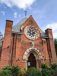 More images |
| Garden Temple in Back Garden of Number 14, The Avenue (Temple House) | Wanstead | Garden Temple | 1730–40 | 20 December 1954 | TQ4080488452 51°34′38″N 0°01′50″E / 51.577352°N 0.030587°E / 51.577352; 0.030587 (Garden Temple in Back Garden of Number 14, The Avenue (Temple House)) | 1357974 |  Upload Photo |
| Gazebo and Grotto Below in Back Garden of Number 20, The Avenue | Wanstead | Gazebo | Early 18th century | 20 December 1954 | TQ4084688480 51°34′39″N 0°01′52″E / 51.577594°N 0.031204°E / 51.577594; 0.031204 (Gazebo and Grotto Below in Back Garden of Number 20, The Avenue) | 1081021 | Upload Photo |
| Godfrey Monument in St Mary's Churchyard | Woodford | Commemorative Monument | c. 1742 | 22 February 1979 | TQ3999690703 51°35′52″N 0°01′11″E / 51.59778°N 0.019831°E / 51.59778; 0.019831 (Godfrey Monument in St Mary's Churchyard) | 1357983 |  More images |
| Hurst House, "The Naked Beauty" | Woodford Green | House | Early 18th century | 20 December 1954 | TQ3998091332 51°36′12″N 0°01′11″E / 51.603436°N 0.019851°E / 51.603436; 0.019851 (Hurst House, "The Naked Beauty") | 1357975 |  |
| Pair of Gatepiers at Entrance to Overton Drive | Wanstead | Gate Pier | 1715–22 | 20 December 1954 | TQ4034787582 51°34′11″N 0°01′25″E / 51.569649°N 0.023649°E / 51.569649; 0.023649 (Pair of Gatepiers at Entrance to Overton Drive) | 1081022 |  |
| Raikes Mausoleum in St Mary's Churchyard | Woodford | Sarcophagus | c. 1797 | 22 February 1979 | TQ3999090737 51°35′53″N 0°01′11″E / 51.598087°N 0.019758°E / 51.598087; 0.019758 (Raikes Mausoleum in St Mary's Churchyard) | 1183475 |  |
| Railings, Gates and Gatepiers to Valentines Park | Ilford | Gate | Late 18th century | 10 April 1954 | TQ4335187771 51°34′14″N 0°04′01″E / 51.570592°N 0.06704°E / 51.570592; 0.06704 (Railings, Gates and Gatepiers to Valentines Park) | 1081027 |  |
| Valentines Mansion | Ilford | Country House | Late 17th century | 10 April 1954 | TQ4329887939 51°34′20″N 0°03′59″E / 51.572115°N 0.066345°E / 51.572115; 0.066345 (Valentines Mansion) | 1081014 |  More images |
Notes
- ^ a b The date given is the date used by Historic England as significant for the initial building or that of an important part in the structure's description.
- ^ a b Sometimes known as OSGB36, the grid reference is based on the British national grid reference system used by the Ordnance Survey.
- ^ a b The "List Entry Number" is a unique number assigned to each listed building and scheduled monument by Historic England.
External links
 Media related to Grade I listed buildings in the London Borough of Redbridge at Wikimedia Commons
- Media related to Grade II* listed buildings in the London Borough of Redbridge at Wikimedia Commons
- v
- t
- e
- Aldersbrook
- Chadwell Heath
- Barkingside (Clayhall, Fairlop, Fullwell Cross, Gants Hill and Hainault)
- Ilford (including Aldborough Hatch, Cranbrook, Gants Hill, Goodmayes, Little Heath, Loxford, Newbury Park, Redbridge and Seven Kings)
- Snaresbrook
- Wanstead
- Woodford (including South Woodford, Woodford Bridge, Woodford Green and Woodford Wells)

- Epping Forest
- Kenneth More Theatre
- Redbridge Museum (currently closed)
- Valentines Mansion
- Chingford and Woodford Green (part)
- Ilford North
- Ilford South
- Leyton and Wanstead (part)
- Clayhall Park
- Hainault Forest Country Park
- Hainault Lodge
- Fairlop Waters
- Goodmayes Park
- Roding Valley Park
- Seven Kings Park
- South Park
- Valentines Park
- Wanstead Flats
- Wanstead Park


- Council
- Grade I and II* listed buildings
- People
- Public art
- Schools
 Category
- Commons

Portals:
 London
 Architecture


