Grade II* listed buildings in Derby
Map all coordinates using OpenStreetMap
Download coordinates as:
- KML
- GPX (all coordinates)
- GPX (primary coordinates)
- GPX (secondary coordinates)
There are over 20,000 Grade II* listed buildings in England. This page is a list of these buildings in the City of Derby in Derbyshire.
List of buildings
| Name | Location | Type | Completed [note 1] | Date designated | Grid ref.[note 2] Geo-coordinates | Entry number [note 3] | Image |
|---|---|---|---|---|---|---|---|
| Allestree Hall | Derby | House | 1802 | 13 February 1967 | SK3464440714 52°57′46″N 1°29′08″W / 52.962679°N 1.485681°W / 52.962679; -1.485681 (Allestree Hall) | 1215234 |  More images |
| Church of All Saints | Mickleover | Church | 14th century | 19 January 1967 | SK3052534203 52°54′16″N 1°32′51″W / 52.904401°N 1.547611°W / 52.904401; -1.547611 (Church of All Saints) | 1216184 |  More images |
| Church of St Anne | Derby | Church | 1871 | 3 July 1998 | SK3442736941 52°55′44″N 1°29′22″W / 52.928778°N 1.489311°W / 52.928778; -1.489311 (Church of St Anne) | 1334930 |  More images |
| Church of St Edmund | Allestree | Church | 12th–13th century | 13 February 1967 | SK3479339714 52°57′13″N 1°29′01″W / 52.953681°N 1.48357°W / 52.953681; -1.48357 (Church of St Edmund) | 1228939 |  More images |
| Church of St John the Evangelist | Derby | Church | 1828 | 20 June 1952 | SK3451836612 52°55′33″N 1°29′17″W / 52.925815°N 1.487992°W / 52.925815; -1.487992 (Church of St John the Evangelist) | 1215810 |  More images |
| Church of St Luke | Derby | Church | Late 19th century | 24 February 1977 | SK3432135626 52°55′01″N 1°29′28″W / 52.916965°N 1.491026°W / 52.916965; -1.491026 (Church of St Luke) | 1279315 |  More images |
| Church of St Mary | Boulton | Church | 12th century | 10 November 1967 | SK3844033038 52°53′36″N 1°25′48″W / 52.893423°N 1.430077°W / 52.893423; -1.430077 (Church of St Mary) | 1287987 |  More images |
| Church of St Peter | Chellaston | Church | 15th century | 10 November 1967 | SK3811730378 52°52′10″N 1°26′07″W / 52.869536°N 1.435189°W / 52.869536; -1.435189 (Church of St Peter) | 1227902 |  More images |
| Church of St Peter and attached boundary walls | Derby | Church | Mid-/late 19th century | 20 June 1952 | SK3530836015 52°55′13″N 1°28′35″W / 52.920398°N 1.476306°W / 52.920398; -1.476306 (Church of St Peter and attached boundary walls) | 1229224 |  More images |
| Church of St Werburgh | Derby | Church | 18th century | 20 June 1952 | SK3497936323 52°55′23″N 1°28′52″W / 52.923188°N 1.481166°W / 52.923188; -1.481166 (Church of St Werburgh) | 1287685 |  More images |
| College of Art Annexe | Derby | Art school | 1876 | 24 February 1977 | SK3519835846 52°55′08″N 1°28′41″W / 52.918886°N 1.47796°W / 52.918886; -1.47796 (College of Art Annexe) | 1227834 |  More images |
| Darley Abbey Mills (north complex) North Mill and engine house and boiler house | Darley Abbey | Mill buildings | c. 1825 | 13 February 1967 | SK3540138634 52°56′38″N 1°28′29″W / 52.943933°N 1.474638°W / 52.943933; -1.474638 (Darley Abbey Mills (north complex) North Mill and engine house and boiler house) | 1067808 |  |
| Darley Abbey Mills (north complex) preparation building and cottage and workshop and cart sheds to north of site | Derby | Mill buildings | 1790s | 13 February 1967 | SK3537238676 52°56′40″N 1°28′30″W / 52.944313°N 1.475065°W / 52.944313; -1.475065 (Darley Abbey Mills (north complex) preparation building and cottage and workshop and cart sheds to north of site) | 1067809 |  Upload Photo |
| Former carriage shop at Derby Railway Works | Derby | Railway works | 1840 | 21 February 1994 | SK3637935646 52°55′01″N 1°27′38″W / 52.917009°N 1.460419°W / 52.917009; -1.460419 (Former carriage shop at Derby Railway Works) | 1278575 | Upload Photo |
| Former engine shed (remains of the original Midland Region Railway Station) | Derby | Railway engineering workshop | c.1830 | 24 February 1977 | SK3636935593 52°55′00″N 1°27′38″W / 52.916534°N 1.460574°W / 52.916534; -1.460574 (Former engine shed (remains of the original Midland Region Railway Station)) | 1228933 |  |
| Former railway workshop at Derby Railway Works | Derby | Turning shop | 19th century | 24 February 1977 | SK3633335699 52°55′03″N 1°27′40″W / 52.917489°N 1.461097°W / 52.917489; -1.461097 (Former railway workshop at Derby Railway Works) | 1230740 |  More images |
| Friary Hotel | Derby | Hotel | Mid-18th century | 20 June 1952 | SK3480336333 52°55′24″N 1°29′02″W / 52.923289°N 1.483783°W / 52.923289; -1.483783 (Friary Hotel) | 1227747 |  More images |
| Green Man Inn | Derby | Public house | 17th century | 20 June 1952 | SK3531335984 52°55′12″N 1°28′34″W / 52.920119°N 1.476235°W / 52.920119; -1.476235 (Green Man Inn) | 1229456 |  More images |
| Midland Railway War Memorial | Derby | War memorial | 1921 | 24 February 1977 | SK3608635478 52°54′56″N 1°27′53″W / 52.915519°N 1.464795°W / 52.915519; -1.464795 (Midland Railway War Memorial) | 1228742 |  More images |
| Old Abbey Building | Darley Abbey | Augustinian monastery | 15th century | 13 February 1967 | SK3525738411 52°56′31″N 1°28′36″W / 52.941938°N 1.476805°W / 52.941938; -1.476805 (Old Abbey Building) | 1287744 |  More images |
| Old Grammar School | Derby | Former school | 16th century | 20 June 1952 | SK3528136002 52°55′13″N 1°28′36″W / 52.920282°N 1.476709°W / 52.920282; -1.476709 (Old Grammar School) | 1279098 | 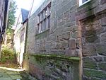 More images |
| Old Hall | Mickleover | Timber-framed house | 1649 | 2 September 1952 | SK3052834024 52°54′10″N 1°32′51″W / 52.902792°N 1.547583°W / 52.902792; -1.547583 (Old Hall) | 1279400 |  |
| Pair of gateways leading to Spondon School (Upper House) and Adult Centre | Spondon | Gate | 18th century | 10 November 1967 | SK3962936096 52°55′15″N 1°24′43″W / 52.920825°N 1.412033°W / 52.920825; -1.412033 (Pair of gateways leading to Spondon School (Upper House) and Adult Centre) | 1279402 | Upload Photo |
| Roman Catholic Church of St Mary | Derby | Church | 1838 | 20 June 1952 | SK3511836792 52°55′39″N 1°28′45″W / 52.927394°N 1.479048°W / 52.927394; -1.479048 (Roman Catholic Church of St Mary) | 1215808 | 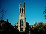 More images |
| Rykneld Mill | Derby | Mill buildings | c. 1808 | 24 February 1977 | SK3474836699 52°55′36″N 1°29′04″W / 52.926582°N 1.484562°W / 52.926582; -1.484562 (Rykneld Mill) | 1215910 |  |
| Stone House Prebend | Derby | Farmhouse | Late 16th century | 20 June 1952 | SK3524937485 52°56′01″N 1°28′37″W / 52.933615°N 1.477025°W / 52.933615; -1.477025 (Stone House Prebend) | 1228772 | Upload Photo |
| St Mary's Bridge | Derby | Bridge | 18th century | 20 June 1952 | SK3538436766 52°55′38″N 1°28′30″W / 52.927143°N 1.475094°W / 52.927143; -1.475094 (St Mary's Bridge) | 1215897 | 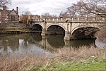 More images |
| Wardwick Tavern Public House | Derby | Public house | Early 18th century | 20 June 1952 | SK3508936205 52°55′20″N 1°28′46″W / 52.92212°N 1.479543°W / 52.92212; -1.479543 (Wardwick Tavern Public House) | 1229898 |  More images |
| 27 Friar Gate | Derby | House | Mid-18th century | 20 June 1952 | SK3474336396 52°55′26″N 1°29′05″W / 52.923859°N 1.484669°W / 52.923859; -1.484669 (27 Friar Gate) | 1216457 | 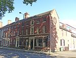 More images |
| 42 Friar Gate | Derby | House | Mid-18th century | 20 June 1952 | SK3464336464 52°55′28″N 1°29′10″W / 52.924477°N 1.486149°W / 52.924477; -1.486149 (42 Friar Gate) | 1216463 |  More images |
| 43–44 Friar Gate | Derby | House | Mid-18th century | 20 June 1952 | SK3462836458 52°55′28″N 1°29′11″W / 52.924424°N 1.486372°W / 52.924424; -1.486372 (43–44 Friar Gate) | 1216527 |  More images |
| 47–51 Friar Gate | Derby | Building | Late 18th century | 20 June 1952 | SK3459236480 52°55′29″N 1°29′13″W / 52.924624°N 1.486906°W / 52.924624; -1.486906 (47–51 Friar Gate) | 1287582 |  More images |
| 99 Friar Gate | Derby | House | Mid-18th century | 20 June 1952 | SK3470636374 52°55′25″N 1°29′07″W / 52.923664°N 1.485221°W / 52.923664; -1.485221 (99 Friar Gate) | 1216586 |  More images |
| 35–36 St Mary's Gate | Derby | Building | Early/mid-18th century | 20 June 1952 | SK3510436459 52°55′28″N 1°28′45″W / 52.924402°N 1.479292°W / 52.924402; -1.479292 (35–36 St Mary's Gate) | 1279144 |  More images |
| 1 and 2 Brick Row | Darley Abbey | Former school | 1826 | 13 February 1967 | SK3509338443 52°56′32″N 1°28′45″W / 52.942237°N 1.479242°W / 52.942237; -1.479242 (1 and 2 Brick Row) | 1287988 | 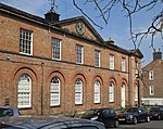 More images |
| 3–16 Brick Row | Darley Abbey | Workers' cottage | Late 18th or early 19th century | 24 February 1977 | SK3512038489 52°56′34″N 1°28′44″W / 52.942648°N 1.478835°W / 52.942648; -1.478835 (3–16 Brick Row) | 1287923 | 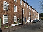 More images |
| 33 Wardwick | Derby | House | 17th century | 20 June 1952 | SK3504936229 52°55′20″N 1°28′48″W / 52.922338°N 1.480135°W / 52.922338; -1.480135 (33 Wardwick) | 1278869 |  More images |
| 48 Sadler Gate | Derby | Town house | 1675 | 20 June 1952 | SK3515936314 52°55′23″N 1°28′43″W / 52.923095°N 1.47849°W / 52.923095; -1.47849 (48 Sadler Gate) | 1279059 |  More images |
See also
- Grade I listed buildings in Derbyshire
- Grade II* listed buildings in Derbyshire
- Grade II* listed buildings in Amber Valley
- Grade II* listed buildings in Bolsover (district)
- Grade II* listed buildings in Chesterfield
- Grade II* listed buildings in Derbyshire Dales
- Grade II* listed buildings in Erewash
- Grade II* listed buildings in High Peak
- Grade II* listed buildings in North East Derbyshire
- Grade II* listed buildings in South Derbyshire
Notes
- ^ The date given is the date used by Historic England as significant for the initial building or that of an important part in the structure's description.
- ^ Sometimes known as OSGB36, the grid reference is based on the British national grid reference system used by the Ordnance Survey.
- ^ The "List Entry Number" is a unique number assigned to each listed building and scheduled monument by Historic England.
External links
- v
- t
- e
- Bedfordshire
- Berkshire
- Bristol
- Buckinghamshire
- Cambridgeshire
- Cheshire
- Cornwall
- Cumbria
- Derbyshire
- Devon
- Dorset
- Durham
- East Sussex
- East Riding of Yorkshire
- Essex
- Gloucestershire
- Greater London
- Greater Manchester
- Hampshire
- Herefordshire
- Hertfordshire
- Isle of Wight
- Kent
- Lancashire
- Leicestershire
- Lincolnshire
- Merseyside
- Norfolk
- North Yorkshire
- Northamptonshire
- Northumberland
- Nottinghamshire
- Oxfordshire
- Rutland
- Shropshire
- Somerset
- South Yorkshire
- Staffordshire
- Suffolk
- Surrey
- Tyne and Wear
- Warwickshire
- West Midlands
- West Sussex
- West Yorkshire
- Wiltshire
- Worcestershire
- Allerdale
- Amber Valley
- Ashford
- Babergh
- Barrow-in-Furness
- Basildon
- Basingstoke and Deane
- Bath and North East Somerset
- Bolsover
- Boston
- Bournemouth
- Bradford
- Braintree
- Breckland
- Brentwood
- Brighton and Hove
- Bristol
- Broadland
- Calderdale
- Cambridge
- Camden
- Canterbury
- Carlisle
- Castle Point
- Chelmsford
- Cheltenham
- Cherwell
- Cheshire East
- Cheshire West and Chester
- Chesterfield
- Chiltern
- Christchurch
- Colchester
- Copeland
- Corby
- Cotswold
- Dartford
- Daventry
- Dover
- East Cambridgeshire
- Exeter
- Mendip
- North Somerset
- North Yorkshire (district)
- Poole
- Sedgemoor
- South Somerset
- Stoke-on-Trent
- Taunton Deane
- West Somerset
- York


