Gáborján
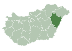
Place in Hajdú-Bihar, Hungary
Gáborján | |
|---|---|
| Country |  Hungary Hungary |
| County | Hajdú-Bihar |
| Area | |
| • Total | 26.46 km2 (10.22 sq mi) |
| Population (2015) | |
| • Total | 863[1] |
| • Density | 32.6/km2 (84/sq mi) |
| Time zone | UTC+1 (CET) |
| • Summer (DST) | UTC+2 (CEST) |
| Postal code | 4122 |
| Area code | 54 |
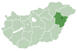
Gáborján is a village in Hajdú-Bihar county, in the Northern Great Plain region of eastern Hungary.
Geography
It covers an area of 26.46 km2 (10 sq mi) and has a population of 863 people (2015).[1]
References
- ^ a b Gazetteer of Hungary, 1 January 2015. Hungarian Central Statistical Office. 3 September 2015
- v
- t
- e
- Debrecen (county seat)
- Álmosd
- Ártánd
- Bakonszeg
- Báránd
- Bedő
- Berekböszörmény
- Bihardancsháza
- Biharnagybajom
- Bihartorda
- Bocskaikert
- Bojt
- Darvas
- Ebes
- Esztár
- Folyás
- Fülöp
- Furta
- Gáborján
- Görbeháza
- Hajdúbagos
- Hajdúszovát
- Hencida
- Hortobágy
- Kismarja
- Kokad
- Konyár
- Körösszakál
- Körösszegapáti
- Magyarhomorog
- Mezőpeterd
- Mezősas
- Mikepércs
- Monostorpályi
- Nagyhegyes
- Nagykereki
- Nyíracsád
- Nyírmártonfalva
- Sáp
- Sáránd
- Szentpéterszeg
- Szerep
- Tépe
- Tetétlen
- Tiszagyulaháza
- Told
- Újiráz
- Újléta
- Újszentmargita
- Újtikos
- Váncsod
- Vekerd
- History
- Geography
- Government
- Economy
- Culture
- Tourism
| Authority control databases |
|
|---|
47°14′N 21°40′E / 47.233°N 21.667°E / 47.233; 21.667
 | This Hajdú-Bihar location article is a stub. You can help Wikipedia by expanding it. |
- v
- t
- e


