Fulda (district)
Administrative division in Hesse, Germany
You can help expand this article with text translated from the corresponding article in German. (April 2021) Click [show] for important translation instructions.
- Machine translation, like DeepL or Google Translate, is a useful starting point for translations, but translators must revise errors as necessary and confirm that the translation is accurate, rather than simply copy-pasting machine-translated text into the English Wikipedia.
- Do not translate text that appears unreliable or low-quality. If possible, verify the text with references provided in the foreign-language article.
- You must provide copyright attribution in the edit summary accompanying your translation by providing an interlanguage link to the source of your translation. A model attribution edit summary is
Content in this edit is translated from the existing German Wikipedia article at [[:de:Landkreis Fulda]]; see its history for attribution. - You may also add the template
{{Translated|de|Landkreis Fulda}}to the talk page. - For more guidance, see Wikipedia:Translation.
District in Hesse, Germany

Flag

Coat of arms

(31 December 2022)[1]
The Fulda District (German: Landkreis Fulda; German pronunciation: [ˈfʊlda]) is a Kreis (district) in the north-east of Hesse, Germany. Neighboring districts are Hersfeld-Rotenburg, Wartburgkreis, Schmalkalden-Meiningen, Rhön-Grabfeld, Bad Kissingen, Main-Kinzig, Vogelsbergkreis.
History
The district was created in 1821, when the duchy of Fulda became a province of Hesse, and was split into four districts. In 1866 the north of Hesse became a part of Prussia, including the Gersfeld area which previously belonged to Bavaria. In 1927 the city of Fulda left the district to become a district-free city, and in 1932 the remaining district was merged with the district of Gersfeld. In 1972, the previously small municipalities were merged into 23 bigger ones, and in 1974 the city of Fulda lost its status as district-free city and joined the district again. In 1972 the major part of the Hünfeld district was added to the district.
Geography
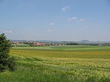
The district is located in the Rhön and Vogelsberg mountains. The main river of the district is the Fulda.
Coat of arms
The left side of the coat of arms shows a black cross, the sign of the monastery of Fulda. The lion on the right side is taken from the Hesse coat of arms, symbolizing that the district was part of Hesse 1821–1866, and again after 1945. The coat of arms was granted in 1936.
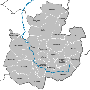
Towns and municipalities
| Towns | Municipalities | |
|---|---|---|
References
- ^ "Bevölkerung in Hessen am 31.12.2022 nach Gemeinden" (XLS) (in German). Hessisches Statistisches Landesamt. June 2023.
External links
Wikimedia Commons has media related to Landkreis Fulda.
- Official website (German)
- allround Informationportal of Fulda
- 360 degree virtual tour through the hessian rhoen
- v
- t
- e


Kassel government region | |
|---|---|
| Urban Districts (kreisfreie Städte) | |
| Rural districts (Landkreise) |
|
Darmstadt government region | |
|---|---|
| Urban Districts (kreisfreie Städte) | |
| Rural districts (Landkreise) |
|
Giessen government region | |
|---|---|
| Urban Districts (kreisfreie Städte) | none |
| Rural districts (Landkreise) |
|
50°30′N 9°40′E / 50.5°N 9.67°E / 50.5; 9.67
Authority control databases | |
|---|---|
| International |
|
| National |
|


