Charlottetown Boulder Park
Boulder park in Prince Edward Island
46°14′08″N 63°07′33″W / 46.2355°N 63.12587°W / 46.2355; -63.12587Charlottetown Boulder Park is an outdoor boulder park located in Charlottetown, Prince Edward Island. The park is located on the northern side of the Honourable George Coles Building, adjacent to Province House.[1]
History
The park was the idea of Dr. Eric Harvie, chairman of the Fathers of Confederation Memorial Citizens Foundation, and includes boulders from each of the Canadian provinces; each boulder includes a plaque that identifies the provinces from which the boulder came, along with the geological name of the rock formation. Harvie intended the park to commemorate the contribution of people from across Canada to the creation of the Confederation Centre of the Arts.[2][3]
Opening
The park opened in a ceremony on September 1, 1966, the 102nd anniversary of the start of the Charlottetown Conference.[2][3] The landscaping for the park was funded by the Bank of Nova Scotia; Graham Scott, manager of the Charlottetown branch, and Dr. Frank MacKinnon, Chair of the Fathers of Confederation Memorial Trust, cut the ribbon.[3]
Boulders
| Province | Boulder Type | Photo | Plaque | Location |
|---|---|---|---|---|
| Alberta | Devonian Dolomite |  |  | 46°14′09″N 63°07′33″W / 46.235768°N 63.12575°W / 46.235768; -63.12575 |
| British Columbia | Quartz Diorite |  | 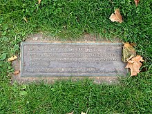 | 46°14′09″N 63°07′32″W / 46.235814°N 63.125654°W / 46.235814; -63.125654 |
| Manitoba | Tyndall Limestone |  |  | 46°14′08″N 63°07′34″W / 46.235511°N 63.126098°W / 46.235511; -63.126098 |
| New Brunswick | Limestone Containing Archaeozoon acadiense | 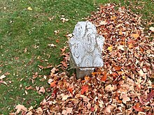 |  | 46°14′07″N 63°07′32″W / 46.2354°N 63.125661°W / 46.2354; -63.125661 |
| Newfoundland | Lower Ordovician Limestone |  |  | 46°14′08″N 63°07′34″W / 46.235426°N 63.126028°W / 46.235426; -63.126028 |
| Nova Scotia | North Mountain Basalt |  | 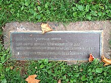 | 46°14′08″N 63°07′33″W / 46.235686°N 63.12572°W / 46.235686; -63.12572 |
| Ontario | Biotite Hornblende Gneiss |  |  | 46°14′08″N 63°07′31″W / 46.235606°N 63.125415°W / 46.235606; -63.125415 |
| Prince Edward Island | Sandstone |  |  | 46°14′08″N 63°07′34″W / 46.235583°N 63.12599°W / 46.235583; -63.12599 |
| Quebec | Anorthosite | 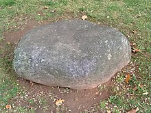 | 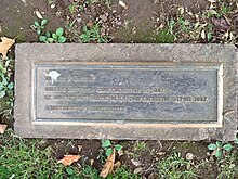 | 46°14′08″N 63°07′33″W / 46.235556°N 63.125732°W / 46.235556; -63.125732 |
| Saskatchewan | Granite |  |  | 46°14′07″N 63°07′33″W / 46.235337°N 63.125816°W / 46.235337; -63.125816 |
| Canada | Jasper Conglomerate |  |  | 46°14′08″N 63°07′33″W / 46.235469°N 63.125855°W / 46.235469; -63.125855 |
Map of boulder locations
Boulders are sited over 1,000 square metres (0.25 acres) site between Church Street and Province House, just south of Grafton Street.


30m
33yds
33yds
11
10
9
8
7
6
5
4
3
2
1
Map showing location of boulders in Charlottetown Boulder Park
1
Alberta2
British Columbia3
Manitoba4
New Brunswick5
Newfoundland6
Nova Scotia7
Ontario8
Prince Edward Island9
Quebec10
Saskatchewan11
CanadaReferences
- ^ Macdougall, Gary (6 September 2014). "Rocks that Rock". The Guardian (Charlottetown). p. 13.
- ^ a b Bond, Anne (2 September 1966). "Boulder Park And Flagpoles Dedicated At Plaza Ceremony". The Guardian (Charlottetown). pp. 1, 3.
- ^ a b c Bond, Anne (2 September 1966). "Dedication ceremony held on Centre plaza". The Evening Patriot (Charlottetown). p. 2.
- v
- t
- e
- Alberton Court House
- All Souls' Chapel
- Apothecaries Hall
- Ardgowan
- Charlottetown City Hall
- Confederation Centre of the Arts
- Dalvay-by-the-Sea
- Dundas Terrace
- Fairholm
- Farmers' Bank of Rustico
- Former Summerside Post Office
- Government House
- Great George Street Historic District
- Jean-Pierre Roma at Three Rivers
- Kensington Railway Station
- L.M. Montgomery's Cavendish
- Old Princetown Road
- Province House
- Shaw's Hotel
- Skmaqn–Port-la-Joye–Fort Amherst
- St. Dunstan's Roman Catholic Basilica
- Strathgartney Homestead
- Tryon United Church
- Boulder Park
- Victoria Park
 Category
 Commons


