Castle Ditches
Iron Age hillfort in Wiltshire, England
51°03′14″N 2°03′15″W / 51.0540°N 2.0542°W / 51.0540; -2.0542
Scheduled monument
Castle Ditches is the site of an Iron Age trivallate hillfort in the south-east of Tisbury parish in Wiltshire, England.
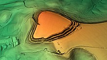
It is probable that its ancient name was Spelsbury; it was referred to as Willburge in Tisbury's charter of 984 A.D.[1] Its shape is roughly triangular, and follows the contours of the small hill upon which it sits. The earthworks comprise a triple row of ramparts and ditches, now covered on three sides by woodland. There is a large entrance towards the south-east, where there is the shallowest incline of the hill; but there is also a narrow slit on the opposite side. The area within the site encompasses nearly 24 acres (9.7 ha), and the greatest height of the ramparts is about 40 feet (12 m).[2][3]
Castle Ditches was recorded as a Scheduled Monument in 1932.[4]
Location
The site is at grid reference ST964282, about 1+1⁄2 miles (2.4 km) south-east of Tisbury village. The hill has a summit of 193m AOD and overlooks the valley of the River Nadder to the north. Public footpaths surround the site, but the land is privately owned.
See also
References
- ^ Tisbury Local History Society (1984). Looking Around Tisbury. Castle Cary, Somerset: Inkwell Design & Print.
- ^ The Ancient History of Wiltshire, by Sir Richard Colt Hoare, published 1812, Chapter No. 11 - Station 8: Fovant
- ^ "Castle Ditches (Wiltshire)". The Megalithic Portal. Retrieved 13 April 2020.
- ^ Historic England. "Castle Ditches camp (1005701)". National Heritage List for England. Retrieved 13 April 2020.
- v
- t
- e
- Mowsbury Hill
- Maiden Bower
- Bussock Camp
- Caesar's Camp
- Grimsbury Castle
- Membury Camp
- Perborough Castle
- Walbury Camp
- Black Head
- Cadson Bury
- Caer Bran
- Castallack Round
- Castle an Dinas
- Castle Dore
- Castle Goff
- Chûn Castle
- Dodman Point
- Giant's Castle
- Kelly Rounds
- Kelsey Head
- Lescudjack
- Lesingey Round
- Maen Castle
- Padderbury Top
- Prideaux Castle
- Rame Head
- The Rumps
- Trencrom Hill
- Trereen Dinas
- Treryn Dinas
- Trevelgue Head
- Warbstow Bury
- Ashleys Copse
- Buckland Rings
- Bury Hill
- Caesar's Camp
- Castle Hill
- Chilworth Ring
- Danebury
- Dunwood Camp
- Frankenbury Camp
- The Frith
- Gorley Hill
- Hamble Common Camp
- King John's Hill
- Knoll Camp
- Ladle Hill
- Lockerley Camp
- Norsebury Ring
- Old Winchester Hill
- Oram's Arbour
- Quarley Hill
- St. Catherine's Hill
- Tidbury Ring
- Toothill Fort
- Whitsbury Castle
- Woolbury
- Bayston Hill
- Bury Ditches
- Bury Walls
- Caer Caradoc, Church Stretton
- Caer Caradog, Chapel Lawn
- Caus Castle
- Coxall Knoll
- Nordy Bank
- Old Oswestry
- The Wrekin
- Carl Wark
- Wincobank
- Ashleys Copse
- Barbury Castle
- Battlesbury Camp
- Bratton Castle
- Bury Camp
- Castle Ditches
- Casterley Camp
- Castle Rings
- Chisbury
- Chiselbury
- Chisenbury Camp
- Clearbury Ring
- Cley Hill
- Fosbury Camp
- Grovely Castle
- Knook Castle
- Liddington Castle
- Membury Camp
- Old Sarum
- Ringsbury Camp
- Roundway Down
- Scratchbury Camp
- Sidbury Hill
- Vespasian's Camp
- Winkelbury Camp
- Yarnbury Castle


