Canapi
You can help expand this article with text translated from the corresponding article in Portuguese. Click [show] for important translation instructions.
- Machine translation, like DeepL or Google Translate, is a useful starting point for translations, but translators must revise errors as necessary and confirm that the translation is accurate, rather than simply copy-pasting machine-translated text into the English Wikipedia.
- Do not translate text that appears unreliable or low-quality. If possible, verify the text with references provided in the foreign-language article.
- You must provide copyright attribution in the edit summary accompanying your translation by providing an interlanguage link to the source of your translation. A model attribution edit summary is
Content in this edit is translated from the existing Portuguese Wikipedia article at [[:pt:Canapi]]; see its history for attribution. - You may also add the template
{{Translated|pt|Canapi}}to the talk page. - For more guidance, see Wikipedia:Translation.
Municipality in Alagoa, Brazil
Place in Northeast, Brazil
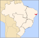
9°7′5″S 37°36′18″W / 9.11806°S 37.60500°W / -9.11806; -37.60500 Brazil
 Alagoas
 (2022)
57530-000[6]
Carié is a municipality located in the Brazilian state of Alagoas. Its population is 17,719 (2020)[7] and its area is 572 km².[8]
Gallery
-
 Povoado Carié neighborhood
 -
 Povoado Carié neighborhood
 -
 Povoado Carié neighborhood
 -
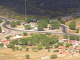 Intersection between Federal Highway 316 (BR-316) and Federal Highway 423 (BR-423)
 -
 Serra of Povoado


See also
References
- ^ a b c "Canapi". Instituto Brasileiro de Geografia e Estatística. Instituto Brasileiro de Geografia e Estatística. Retrieved 5 September 2024.
- ^ "História & Fotos". Instituto Brasileiro de Geografia e Estatística. Instituto Brasileiro de Geografia e Estatística. Retrieved 5 September 2024.
- ^ "Prefeito Municipal". Prefeitura Municipal de Canapi - Alagoas. Prefeitura Municipal de Canapi - Alagoas. Retrieved 5 September 2024.
- ^ a b "Prefeito e vereadores de Canapi tomam posse; veja lista de eleitos". globo.com. globo.com. Retrieved 5 September 2024.
- ^ "Vice-Prefeito Municipal". Prefeitura Municipal de Canapi - Alagoas. Prefeitura Municipal de Canapi - Alagoas. Retrieved 5 September 2024.
- ^ "Código Postal Canapi/AL - Brasil". Código Postal. Código Postal. Retrieved 5 September 2024.
- ^ IBGE 2020
- ^ IBGE - "Archived copy". Archived from the original on 11 June 2008. Retrieved 11 June 2008.
{{cite web}}: CS1 maint: archived copy as title (link)
- v
- t
- e
Capital: Maceió
- Água Branca
- Canapi
- Inhapi
- Mata Grande
- Pariconha
 | This Alagoas, Brazil location article is a stub. You can help Wikipedia by expanding it. |
- v
- t
- e


