California Historical Landmarks in Calaveras County
Map all coordinates using OpenStreetMap
Download coordinates as:
- KML
- GPX (all coordinates)
- GPX (primary coordinates)
- GPX (secondary coordinates)
List table of the properties and districts — listed on the California Historical Landmarks — within Calaveras County, California.
- Note: Click the "Map of all coordinates" link to the right to view a Google map of all properties and districts with latitude and longitude coordinates in the table below.
Listings
| Image | [1] | Landmark name | Location | City or town | Summary |
|---|---|---|---|---|---|
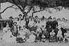
 Upload Photo | 288 | Altaville | State Hwy 49 & Hwy 4 38°04′46″N 120°33′18″W / 38.079583°N 120.555133°W / 38.079583; -120.555133 (Altaville) | Altaville | |
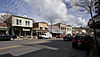 | 287 | Angels Camp | Historic district 38°04′07″N 120°32′22″W / 38.06850°N 120.53944°W / 38.06850; -120.53944 (Angels Camp) | Angels Camp | |
 | 734 | Angels Hotel | Main St. and Birds Way 38°04′07″N 120°32′21″W / 38.06871°N 120.53908°W / 38.06871; -120.53908 (Angels Hotel) | Angels Camp | Also on the NRHP list as NPS-72000220 |
 | 41 | Big Bar (Amador County, California) | 38°18′43″N 120°43′12″W / 38.311944°N 120.72°W / 38.311944; -120.72 (Big Bar (Amador County, California)) | Jackson | Big Bar mine is in both Calaveras County and Amador County |
Upload Photo | 769 | Birthplace of Archie Stevenot | State Hwy 4, 3.7 miles south of Angels Camp 38°01′40″N 120°30′24″W / 38.02765°N 120.506667°W / 38.02765; -120.506667 (Birthplace of Archie Stevenot) | Angels Camp | |
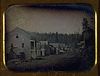
Upload Photo | 465 | Old mining camp of Brownsville | Pennsylvania Gulch Rd. 38°07′43″N 120°26′31″W / 38.128667°N 120.44195°W / 38.128667; -120.44195 (Old mining camp of Brownsville) | Murphys | |
Upload Photo | 255 | Calaveritas | Historic district 38°09′28″N 120°36′44″W / 38.157778°N 120.612222°W / 38.157778; -120.612222 (Calaveritas) | Calaveritas | |
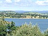
 | 254 | Camanche | Historic district 38°12′48″N 120°56′07″W / 38.213333°N 120.935278°W / 38.213333; -120.935278 (Camanche) | Camanche | |
Upload Photo | 257 | Campo Seco | Historic district 38°13′38″N 120°51′12″W / 38.227222°N 120.853333°W / 38.227222; -120.853333 (Campo Seco) | Campo Seco | |
 | 956 | California Caverns | Cave City Rd. 38°12′10″N 120°30′32″W / 38.202872°N 120.508847°W / 38.202872; -120.508847 (California Caverns) | Cave City | |
Upload Photo | 274 | Carson Hill | Historic district 38°01′42″N 120°30′24″W / 38.028333°N 120.506667°W / 38.028333; -120.506667 (Carson Hill) | Carson Hill | |
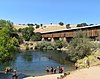
Upload Photo | 265 | Chili Gulch | Double Springs Rd. 38°12′58″N 120°42′27″W / 38.216029°N 120.707433°W / 38.216029; -120.707433 (Chili Gulch) | Mokelumne Hill | |
 | 261 | Congregational Church | Northeast corner of Main and Church Sts. 38°18′00″N 120°42′23″W / 38.299992°N 120.706488°W / 38.299992; -120.706488 (Congregational Church) | Mokelumne Hill | |
 | 296 | Copperopolis | Historic district 37°58′41″N 120°38′18″W / 37.977967°N 120.638433°W / 37.977967; -120.638433 (Copperopolis) | Copperopolis | |
 | 663 | Courthouse of Calaveras County and the Léger Hotel | Corner of Main & Lafayette Sts. 38°18′04″N 120°42′21″W / 38.301067°N 120.705783°W / 38.301067; -120.705783 (Courthouse of Calaveras County and the Léger Hotel) | Mokelumne Hill | This was the county courthouse from 1852-1866 |
 | 264 | Double Springs | Double Springs Rd. 38°12′19″N 120°47′28″W / 38.205183°N 120.79115°W / 38.205183; -120.79115 (Double Springs) | Valley Springs | |
 | 272 | Douglas Flat | Historic district 38°06′52″N 120°27′18″W / 38.114444°N 120.455°W / 38.114444; -120.455 (Douglas Flat) | Douglas Flat | |
Upload Photo | 282 | El Dorado | Mountain Ranch Rd. & Whiskey Slide Rd. 38°13′42″N 120°32′27″W / 38.228333°N 120.540833°W / 38.228333; -120.540833 (El Dorado) | Mountain Ranch | |
Upload Photo | 258 | Fourth Crossing | Historic district 38°07′53″N 120°38′05″W / 38.131389°N 120.634722°W / 38.131389; -120.634722 (Fourth Crossing) | Fourth Crossing | |
Upload Photo | 280 | Glencoe | Historic district 38°21′15″N 120°35′06″W / 38.354167°N 120.585°W / 38.354167; -120.585 (Glencoe) | Glencoe | |
 | 256 | I.O.O.F. Hall | Northeast corner of Main and Center Sts. 38°18′08″N 120°42′22″W / 38.302158°N 120.705978°W / 38.302158; -120.705978 (I.O.O.F. Hall) | Mokelumne Hill | |
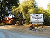
Upload Photo | 266 | Jenny Lind | 38°05′42″N 120°52′12″W / 38.095°N 120.87°W / 38.095; -120.87 (Jenny Lind) | Jenny Lind | |
Upload Photo | 284 | Jesus Maria | Historic district 38°17′08″N 120°38′51″W / 38.285556°N 120.6475°W / 38.285556; -120.6475 (Jesus Maria) | Jesus Maria | |
Upload Photo | 262 | Milton | Historic district 38°01′55″N 120°51′08″W / 38.031944°N 120.852222°W / 38.031944; -120.852222 (Milton) | Milton | |
 | 269 | Mokelumne Hill | 38°18′02″N 120°42′23″W / 38.300556°N 120.706389°W / 38.300556; -120.706389 (Mokelumne Hill) | Mokelumne Hill | |
 | 275 | Murphys | Historic district 38°08′15″N 120°27′35″W / 38.1375°N 120.459722°W / 38.1375; -120.459722 (Murphys) | Murphys | |
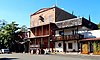
 | 267 | Murphys Hotel | 457 Main at Algiers St. 38°08′16″N 120°27′54″W / 38.1377°N 120.464983°W / 38.1377; -120.464983 (Murphys Hotel) | Murphys | Also known as Mitchler Hotel. Also on the NRHP list as NPS-71000134 |
 | 281 | O'Byrne Ferry | O'Byrne Ferry Rd. 37°53′49″N 120°34′34″W / 37.896933°N 120.576117°W / 37.896933; -120.576117 (O'Byrne Ferry) | Copperopolis | |
Upload Photo | 295 | Paloma | Paloma Rd. & Edster St. 38°15′33″N 120°45′42″W / 38.259133°N 120.76155°W / 38.259133; -120.76155 (Paloma) | Paloma | |
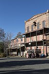
Upload Photo | 466 | Peter L. Traver Building | 470 Main St. 38°08′16″N 120°27′54″W / 38.1378°N 120.4651°W / 38.1378; -120.4651 (Peter L. Traver Building) | Murphys | |
Upload Photo | 271 | Pioneer Cemetery | State Hwy 12, .7 miles west of State Hwy 49 junction 38°12′31″N 120°42′29″W / 38.208613°N 120.707967°W / 38.208613; -120.707967 (Pioneer Cemetery) | San Andreas | |
Upload Photo | 735 | Prince-Garibaldi Building | 298 S. Main St. 38°04′46″N 120°33′15″W / 38.079317°N 120.554167°W / 38.079317; -120.554167 (Prince-Garibaldi Building) | Altaville | |
Upload Photo | 286 | Rail Road Flat | Historic district 38°20′36″N 120°30′44″W / 38.343333°N 120.512222°W / 38.343333; -120.512222 (Rail Road Flat) | Rail Road Flat | |
 | 499 | Red Brick Grammar School | 125 N. Main St. 38°04′59″N 120°33′43″W / 38.082977°N 120.561869°W / 38.082977; -120.561869 (Red Brick Grammar School) | Altaville | Also on the NRHP list as NPS-79000471 |
Upload Photo | 276 | Robinson's Ferry | Vista point on State Hwy 49 38°00′33″N 120°30′17″W / 38.009083°N 120.50475°W / 38.009083; -120.50475 (Robinson's Ferry) | Angels Camp | |
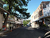 | 252 | San Andreas | Historic district 38°11′46″N 120°40′50″W / 38.196111°N 120.680556°W / 38.196111; -120.680556 (San Andreas) | San Andreas | |
 | 253 | Sandy Gulch | Historic district 38°22′49″N 120°31′58″W / 38.380278°N 120.532778°W / 38.380278; -120.532778 (Sandy Gulch) | Sandy Gulch | |
 | 263 | Stone Corral | Stone Corral Ranch, Hwy 26, 38°06′06″N 120°55′35″W / 38.101604°N 120.926384°W / 38.101604; -120.926384 (Stone Corral) | Rancho Calaveras | |
Upload Photo | 273 | Vallecito | Historic district 38°05′25″N 120°28′25″W / 38.090278°N 120.473611°W / 38.090278; -120.473611 (Vallecito) | Vallecito | |
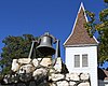 | 370 | Vallecito Bell Monument | Church St. & Cemetery Ln. 38°05′11″N 120°28′27″W / 38.086367°N 120.474133°W / 38.086367; -120.474133 (Vallecito Bell Monument) | Vallecito | |
Upload Photo | 251 | Valley Springs | Historic district 38°11′30″N 120°49′45″W / 38.191667°N 120.829167°W / 38.191667; -120.829167 (Valley Springs) | Valley Springs | |
Upload Photo | 268 | West Point | Historic district 38°23′57″N 120°31′39″W / 38.399167°N 120.5275°W / 38.399167; -120.5275 (West Point) | West Point |
See also
Wikimedia Commons has media related to California Historical Landmarks in Calaveras County, California.
- List of California Historical Landmarks
- National Register of Historic Places listings in Calaveras County, California
References
- ^ "California Historical Landmarks By County". Ohp.parks.ca.gov. Retrieved 2019-04-03.
- v
- t
- e
| |||||||||||||||||
National Forests and Grasslands | |||||||
|---|---|---|---|---|---|---|---|
| |||||||
|
| |||||||
| |||||||
|
|
- Heritage registers
- National Natural Landmarks


