Bredstedt-Land
Former Amt in Germany

Flag
Coat of arms
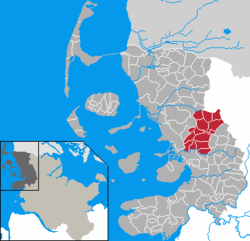
Map of Nordfriesland highlighting Bredstedt-Land
Bredstedt-Land was an Amt ("collective municipality") in the district of Nordfriesland, in Schleswig-Holstein, Germany. It was situated east of Bredstedt, approx. 15 km north of Husum. Its seat was in Breklum.
In April 2008, it was merged with the Amt Stollberg and the town Bredstedt to form the Amt Mittleres Nordfriesland.[1]
The Amt Bredstedt-Land consisted of the following municipalities (population in 2005 between brackets):
- Ahrenshöft (511)
- Almdorf (533)
- Bohmstedt (755)
- Breklum * (2.325)
- Drelsdorf (1.281)
- Goldebek (353)
- Goldelund (394)
- Högel (470)
- Joldelund (732)
- Kolkerheide (68)
- Lütjenholm (337)
- Sönnebüll (234)
- Struckum (990)
- Vollstedt (165)
References
- ^ "Liste aller Verwaltungszusammenschlüsse in den Gemeinden und Ämtern in Schleswig-Holstein" (PDF). Innenministerium des Landes Schleswig-Holstein (in German). 1 January 2021. p. 6. Archived from the original (PDF) on 1 February 2014. Retrieved 4 February 2024.
- v
- t
- e


The Ämter are listed per district (Kreis)
- Berkenthin
- Breitenfelde
- Büchen
- Hohe Elbgeest
- Lauenburgische Seen
- Lütau
- Sandesneben-Nusse
- Schwarzenbek-Land
- Eiderstedt
- Föhr-Amrum
- Landschaft Sylt
- Mittleres Nordfriesland
- Nordsee-Treene
- Pellworm
- Südtondern
- Viöl
- Großer Plöner See
- Lensahn
- Oldenburg-Land
- Ostholstein-Mitte
- Bokhorst-Wankendorf
- Großer Plöner See
- Lütjenburg
- Preetz-Land
- Probstei
- Schrevenborn
- Selent/Schlesen
- Achterwehr
- Bordesholm
- Dänischenhagen
- Dänischer Wohld
- Eiderkanal
- Eidertal
- Fockbek
- Hohner Harde
- Hüttener Berge
- Jevenstedt
- Mittelholstein
- Nortorfer Land
- Schlei-Ostsee
- Arensharde
- Eggebek
- Geltinger Bucht
- Haddeby
- Hürup
- Kappeln-Land
- Kropp-Stapelholm
- Langballig
- Mittelangeln
- Oeversee
- Schafflund
- Südangeln
- Süderbrarup
- Auenland Südholstein
- Bad Bramstedt-Land
- Boostedt-Rickling
- Bornhöved
- Itzstedt
- Kisdorf
- Leezen
- Trave-Land
- Breitenburg
- Horst-Herzhorn
- Itzehoe-Land
- Kellinghusen
- Krempermarsch
- Schenefeld
- Wilstermarsch
- Bad Oldesloe-Land
- Bargteheide-Land
- Itzstedt
- Nordstormarn
- Siek
- Trittau
| Authority control databases |
|
|---|
54°36′N 8°58′E / 54.600°N 8.967°E / 54.600; 8.967
 | This Nordfriesland location article is a stub. You can help Wikipedia by expanding it. |
- v
- t
- e


