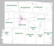
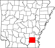
Bartholomew Township, Drew County, Arkansas
Township in Arkansas, United States
33°30′21″N 91°28′04″W / 33.505775°N 91.467687°W / 33.505775; -91.467687[1][1]
[2]
(2010)[1]
Bartholomew Township is a township in Drew County, Arkansas, United States.[4] Its total population was 168 as of the 2010 United States Census,[1][5] a decrease of 24.66 percent from 223 at the 2000 census.[6][7]
According to the 2010 Census, Bartholomew Township is located at 33°30′21″N 91°28′04″W / 33.505775°N 91.467687°W / 33.505775; -91.467687 (33.505775, -91.467687).[1] It has a total area of 75.126 square miles (194.58 square kilometers), of which 74.469 sq mi (192.87 km2) is land and 0.657 sq mi (1.70 km2) is water (0.87%).[1] As per the USGS National Elevation Dataset, the elevation is 138 feet (42 m).[2]
The town of Jerome is located within the township.[4]
References
- ^ a b c d e f "County Subdivisions (2010): Arkansas". 2010 Census Gazetteer Files. United States Census Bureau. Archived from the original (TXT) on May 31, 2014. Retrieved May 31, 2014.
- ^ a b c d "Feature ID 66508: Township of Bartholomew (Drew County, Arkansas)". Geographic Names Information System. United States Geological Survey. Retrieved May 31, 2014.
- ^ a b "FIPS55 Data: Arkansas". FIPS55 Data. United States Geological Survey. February 23, 2006. Archived from the original (TXT) on June 18, 2006. Retrieved May 31, 2014.
- ^ a b "Summary Population and Housing Characteristics, CPH-1-5, Arkansas" (PDF). 2010 Census of Population and Housing. United States Census Bureau. September 2012. Retrieved May 31, 2014.
- ^ "2010 Demographic Profile (DP-1): Bartholomew township, Drew County, Arkansas". American FactFinder. United States Census Bureau. Archived from the original on February 12, 2020. Retrieved May 31, 2014.
- ^ "2000 Demographic Profile (DP-1): Bartholomew township, Drew County, Arkansas". American FactFinder. United States Census Bureau. Archived from the original on February 12, 2020. Retrieved May 31, 2014.
- ^ "County Subdivisions (2000)". 2000 Census Gazetteer Files. United States Census Bureau. Archived from the original (Zipped TXT) on May 31, 2014. Retrieved May 31, 2014.
External links
- "2010 Census Block Map: Bartholomew Township, Arkansas" (PDF). Arkansas 2010 Census Block Maps - County Subdivisions. U.S. Census Bureau.
- "2013 Boundary and Annexation Survey (BAS) Map: Drew County, Arkansas" (PDF). Boundary and Annexation Survey (BAS) Shapefiles and Maps. U.S. Census Bureau. Archived from the original (PDF) on June 2, 2014. Retrieved June 1, 2014.
- "2010 Census County Subdivision Maps: Arkansas" (PDF). County Subdivision Maps. U.S. Census Bureau.
- v
- t
- e
Municipalities and communities of Drew County, Arkansas, United States
County seat: Monticello
communities
‡This populated place also has portions in an adjacent county or counties
- Arkansas portal
- United States portal
 | This article about a location in Drew County, Arkansas is a stub. You can help Wikipedia by expanding it. |
- v
- t
- e


