Atzelberg
You can help expand this article with text translated from the corresponding article in German. (July 2010) Click [show] for important translation instructions.
- View a machine-translated version of the German article.
- Machine translation, like DeepL or Google Translate, is a useful starting point for translations, but translators must revise errors as necessary and confirm that the translation is accurate, rather than simply copy-pasting machine-translated text into the English Wikipedia.
- Do not translate text that appears unreliable or low-quality. If possible, verify the text with references provided in the foreign-language article.
- You must provide copyright attribution in the edit summary accompanying your translation by providing an interlanguage link to the source of your translation. A model attribution edit summary is
Content in this edit is translated from the existing German Wikipedia article at [[:de:Atzelberg]]; see its history for attribution. - You may also add the template
{{Translated|de|Atzelberg}}to the talk page. - For more guidance, see Wikipedia:Translation.
| Atzelberg | |
|---|---|
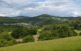 Atzelberg seen from the west | |
| Highest point | |
| Elevation | 507 m (1,663 ft) |
| Geography | |
| Location | Hesse, Germany |
The Atzelberg is a mountain of the Taunus near Eppenhain, constituent community of Kelkheim, Hesse, Germany. Its silhouette is remarkable for a Typenturm radio tower. It is part of the natural region High Taunus although being part of the Main-Taunus-Kreis as well.
50°10′31″N 8°23′17″E / 50.17528°N 8.38806°E / 50.17528; 8.38806
- v
- t
- e


