Alboran Sea
Westernmost portion of the Mediterranean Sea
36°0′N 3°0′W / 36.000°N 3.000°W / 36.000; -3.000Alhucemas and Nador, Morocco, Gibraltar
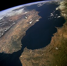
The Alboran Sea is the westernmost portion of the Mediterranean Sea, lying between the Iberian Peninsula and the north of Africa (Spain on the north and Morocco and Algeria on the south). The Strait of Gibraltar, which lies at the west end of the Alboran Sea, connects the Mediterranean with the Atlantic Ocean.
Geography
Its average depth is 445 metres (1,460 ft) and maximum depth is 1,500 metres (4,900 ft).
The International Hydrographic Organization defines the limits of the Alboran Sea as follows:[1]
On the West. The Eastern limit of the Strait of Gibraltar: A line joining from tip (Europa Point) of Cap Gibraltar in Europe to the tip of the Península de Almina of Ceuta in Africa (35°54′N 5°18′W / 35.900°N 5.300°W / 35.900; -5.300).
On the East. A line joining from Cabo de Gata in Andalusia in Europe to Cap Fegalo, near Oran, Algeria in Africa (35°36′N 1°12′W / 35.600°N 1.200°W / 35.600; -1.200).
Several small islands dot the sea, including the eponymous Isla de Alborán. Most, even those close to the African shore, belong to Spain.
Geology
The Alboran domain, the seafloor beneath the Alboran Sea (known as the internal zones) together with the surrounding mountains (known as the external zones; the Gibraltar Arc and Atlas Mountains), is mostly made of continental crust and marks the westernmost terminus of the terranes that were subducted between the African and Eurasian Plates when the Tethys Ocean closed. Reoccurring earthquakes at a depth of about 600 km (370 mi) indicate that this subduction is ongoing and that complex interactions between the lithosphere and mantle are forming the region.[2] The internal zones are made of Late Paleozoic to Triassic rocks that were piled up during the Tertiary and has been extended since the Early Miocene.[3]
The seafloor is morphologically complex with several sub-basins, including three main sub-basins named West, East, and South Alboran Basins, ridges, and seamounts. The most prominent structure in the Alboran Sea is the 180 km long (110 mi) Alboran Ridge which stretches southwest from the volcanic Alborán Island.[4]
Oceanography
Surface currents in the Alboran Sea, influenced by the prevailing winds, flow eastward, bringing water from the Atlantic into the Mediterranean; deeper subsurface currents flow westward, carrying saltier Mediterranean water over the Gibraltar sill into the Atlantic. Thus there is typically a vertical rotary circulation, also known as a gyre, in the Alboran Sea as a result of this exchange of water.[5]
Ecology

The Alboran Sea is a transition zone between ocean and sea, containing a mix of Mediterranean and Atlantic species. The Alboran Sea is habitat for the largest population of bottlenose dolphins and the last population of harbour porpoises in the western Mediterranean, and is the most important feeding grounds for loggerhead sea turtles in Europe. The Alboran sea also hosts important commercial fisheries, including sardines and swordfish. In 2003, the World Wildlife Fund raised concerns about the widespread drift net fishing endangering populations of dolphins, turtles, as well as other marine animals. In 2023, the European Union, Morocco, and Algeria agreed to ban bottom fishing practices around Cabliers Bank, protecting the only cold-water coral reef known to be growing in the Mediterranean.[6]
An arc of mountains, known as the Gibraltar Arc, wraps around the northern, western and southern sides of the Alboran Sea. The Gibraltar Arc is made up of the Baetic Cordillera of Southern Spain and the Rif Mountains of Morocco. These mountains, known to ecologists as the Baetic-Rifan complex, comprise one of the Mediterranean's biodiversity hotspots; like the Alboran Sea, the Baetic-Rifan complex represents a transition between the Mediterranean and Atlantic (Macaronesian) ecological zones. The moderating influence of the Atlantic has allowed many relict species in the Baetic and Rif mountains to survive the climatic fluctuations of the last few million years that have caused them to become extinct elsewhere around the Mediterranean basin.
Islands
There are some small islands in the sea:[7]
References
Notes
- ^ "Limits of Oceans and Seas, 3rd edition" (PDF). International Hydrographic Organization. 1953. Archived from the original (PDF) on 8 October 2011. Retrieved 28 December 2020.
- ^ Alpert et al. 2013, Introduction, pp. 4265–4266.
- ^ Iribarren et al. 2007, Introduction, p. 98.
- ^ Comas et al. 1999, p. 559.
- ^ C. Michael Hogan. 2011. "Alboran Sea" in. eds. P. Saundry & C. J. Cleveland. Encyclopedia of Earth. (National Council for Science and the Environment) Washington DC
- ^ "Mediterranean countries unite to protect unique deep-sea coral from fishing impacts". europe.oceana.org. Retrieved 2023-11-17.
- ^ "Map of Alboran Sea - Alboran Sea Map, World Seas, Alboran Location - World Atlas". www.worldatlas.com. Retrieved 2017-10-12.
- ^ "Alboran Sea - a sea in Atlantic Ocean". www.deepseawaters.com. Retrieved 2017-10-12.
Sources
- Alpert, L. A.; Miller, M. S.; Becker, T. W.; Allam, A. A. (2013). "Structure beneath the Alboran from geodynamic flow models and seismic anisotropy" (PDF). Journal of Geophysical Research: Solid Earth. 118 (8): 4265–4277. doi:10.1002/jgrb.50309. Retrieved 7 November 2015.
- Comas, M. C.; Platt, J. P.; Soto, J. I.; Watts, A. B. (1999). "44. The origin and tectonic history of the Alboran Basin: insights from Leg 161 results". Proceedings of the Ocean Drilling Program Scientific Results. Vol. 161. pp. 555–580. Retrieved 25 October 2015.
- Iribarren, L.; Vergés, J.; Camurri, F.; Fullea, J.; Fernandez, M. (2007). "The structure of the Atlantic–Mediterranean transition zone from the Alboran Sea to the Horseshoe Abyssal Plain (Iberia–Africa plate boundary)". Marine Geology. 243 (1): 97–119. doi:10.1016/j.margeo.2007.05.011. Retrieved 7 November 2015.
- v
- t
- e
- Adriatic Sea
- Aegean Sea
- Alboran Sea
- American Mediterranean Sea
- Archipelago Sea
- Argentine Sea
- Baffin Bay
- Balearic Sea
- Baltic Sea
- Bay of Biscay
- Bay of Bothnia
- Bay of Campeche
- Bay of Fundy
- Black Sea
- Bothnian Sea
- Caribbean Sea
- Celtic Sea
- English Channel
- Foxe Basin
- Greenland Sea
- Gulf of Bothnia
- Gulf of Finland
- Gulf of Guinea
- Gulf of Lion
- Gulf of Maine
- Gulf of Mexico
- Gulf of Sidra
- Gulf of St. Lawrence
- Gulf of Venezuela
- Hudson Bay
- Ionian Sea
- Irish Sea
- Irminger Sea
- James Bay
- Labrador Sea
- Levantine Sea
- Libyan Sea
- Ligurian Sea
- Mediterranean Sea
- Myrtoan Sea
- North Sea
- Norwegian Sea
- Sargasso Sea
- Sea of Åland
- Sea of Azov
- Sea of Crete
- Sea of the Hebrides
- Sea of Marmara
- Thracian Sea
- Tyrrhenian Sea
- Wadden Sea
- Arafura Sea
- Bali Sea
- Banda Sea
- Bering Sea
- Bismarck Sea
- Bohai Sea
- Bohol Sea
- Camotes Sea
- Celebes Sea
- Chilean Sea
- Coral Sea
- East China Sea
- Gulf of Alaska
- Gulf of Anadyr
- Gulf of California
- Gulf of Carpentaria
- Gulf of Fonseca
- Gulf of Panama
- Gulf of Thailand
- Gulf of Tonkin
- Halmahera Sea
- Java Sea
- Koro Sea
- Mar de Grau
- Molucca Sea
- Moro Gulf
- Philippine Sea
- Salish Sea
- Savu Sea
- Sea of Japan
- Sea of Okhotsk
- Seram Sea
- Seto Inland Sea
- Shantar Sea
- Sibuyan Sea
- Solomon Sea
- South China Sea
- Sulu Sea
- Tasman Sea
- Visayan Sea
- Yellow Sea
 Oceans portal
 Category

Marginal seas of the Atlantic Ocean | |
|---|---|
| Basins | |
| Bays | |
| Channels | |
| Gulfs | |
| Seas |
|
 Oceans portal Oceans portal | |
African seas | |
|---|---|
| Oceans and seas | |
| Gulfs and bays |
|
| Straits |
|
| Historical seas | |
 Africa portal Oceans portal Africa portal Oceans portal | |


