ʿAdhaim
River in Iraq
| ʿAdhaim | |
|---|---|
 | |
| Physical characteristics | |
| Length | 230 km (140 mi) |
| Basin size | 12,965 km2 (5,006 sq mi) |
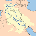
The ʿAdhaim (العظيم) is a river in Iraq that originates in the Zagros Mountains in Sulaymaniyah Governorate and joins the Tigris river after 230 kilometres (140 mi) at 34°00′07″N 44°17′35″E / 34.002°N 44.293°E / 34.002; 44.293, some 30 kilometres (19 mi) downstream (east-to-southeast) of Samarra.
Its basin extends to 12,965 square kilometres (5,006 sq mi). The river is fed by rainwater and peak discharge is between January and March.[1]
See also
- Adhaim Dam
References
- ^ Shahin, Mamdouh (2007), Water Resources and Hydrometeorology of the Arab Region, Dordrecht: Springer, ISBN 978-1-4020-5414-3
- v
- t
- e
The Tigris
- Turkey (523 km)
- Syria (40 km)
- Iraq (1,377 km)
- Diyarbakır
- Bismil
- Hasankeyf
- Cizre
- Mosul
- Tikrit
- Samarra
- Kadhimiya
- Baghdad
- Amarah
- Al-Kūt
- Kemune
34°16′00″N 44°31′00″E / 34.2667°N 44.5167°E / 34.2667; 44.5167
This Iraq river or creek related article is a stub. You can help Wikipedia by expanding it. |
- v
- t
- e


