Saint-Ganton
| Saint-Ganton | ||
|---|---|---|
| ||
| Staat | Frankreich | |
| Region | Bretagne | |
| Département (Nr.) | Ille-et-Vilaine (35) | |
| Arrondissement | Redon | |
| Kanton | Redon | |
| Gemeindeverband | Redon Agglomération | |
| Koordinaten | 47° 46′ N, 1° 53′ W47.765833333333-1.8888888888889Koordinaten: 47° 46′ N, 1° 53′ W | |
| Höhe | 25–102 m | |
| Fläche | 14,08 km² | |
| Einwohner | 419 (1. Januar 2021) | |
| Bevölkerungsdichte | 30 Einw./km² | |
| Postleitzahl | 35550 | |
| INSEE-Code | 35268 | |
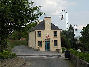 Mairie Saint-Ganton | ||


Saint-Ganton (auf Gallo: Saent-Ganton, auf Bretonisch Sant-Weganton) ist eine französische Gemeinde mit 419 Einwohnern (Stand: 1. Januar 2021) im Département Ille-et-Vilaine in der Region Bretagne. Sie gehört zum Arrondissement Redon und zum Kanton Redon.
Geographie
Die Gemeinde Saint-Ganton liegt 15 Kilometer nordöstlich von Redon. Sie grenzt im Norden an Pipriac, im Nordosten an Guipry-Messac, im Südosten und Süden an Langon und im Westen an Saint-Just. Das Siedlungsgebiet befindet sich ungefähr auf 80 Metern über Meereshöhe.
Bevölkerungsentwicklung
| Jahr | 1962 | 1968 | 1975 | 1982 | 1990 | 1999 | 2011 | 2020 |
| Einwohner | 504 | 490 | 461 | 405 | 381 | 388 | 418 | 424 |
| Quellen: Cassini und INSEE | ||||||||
Sehenswürdigkeiten
- Kirche Saint-Quentin
- Kapellen Saint-Cornély und Saint-Mathurin
- Oratorium Saint-Eutrope
-
 Kirche Saint-Quentin
 -
 Kapelle Saint-Cornély
 -
 Kapelle Saint-Mathurin
 -
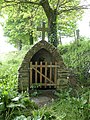 Oratorium Saint-Eutrope


Literatur
- Le Patrimoine des Communes d’Ille-et-Vilaine. Flohic Editions, Band 2, Paris 2000, ISBN 2-84234-072-8, S. 1059–1052.
Weblinks
Commons: Saint-Ganton – Sammlung von Bildern, Videos und Audiodateien


