Redding (Connecticut)
| Redding | |||
|---|---|---|---|
 Das Redding Center in Redding | |||
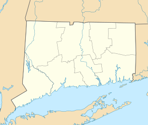
| Lage in Connecticut | |||
| |||
| Basisdaten | |||
| Gründung: | 1767 | ||
| Staat: | Vereinigte Staaten | ||
| Bundesstaat: | Connecticut | ||
| County: | Fairfield County | ||
| Koordinaten: | 41° 18′ N, 73° 24′ W41.304444444444-73.392777777778144Koordinaten: 41° 18′ N, 73° 24′ W | ||
| Zeitzone: | Eastern (UTC−5/−4) | ||
| Einwohner: – Metropolregion: | 8.765 (Stand: 2020) 20.140.470 (Stand: 2020) | ||
| Haushalte: | 3.425 (Stand: 2020) | ||
| Fläche: | 83,1 km² (ca. 32 mi²) davon 81,6 km² (ca. 32 mi²) Land | ||
| Bevölkerungsdichte: | 107 Einwohner je km² | ||
| Höhe: | 144 m | ||
| Postleitzahl: | 06896 | ||
| Vorwahl: | +1 203 | ||
| FIPS: | 09-63480 | ||
| GNIS-ID: | 0213495 | ||
| Website: | www.townofreddingct.org | ||
| Bürgermeister: | Julia Pemberton | ||

Redding ist eine Stadt im Fairfield County im US-amerikanischen Bundesstaat Connecticut. Das U.S. Census Bureau hat bei der Volkszählung 2020 eine Einwohnerzahl von 8.765[1] ermittelt. Die geografischen Koordinaten sind: 41,18° Nord, 73,23° West. Das Stadtgebiet hat eine Größe von 83,1 km².
Redding ist Namensgeberin für das erstmals im nahegelegenen Steinbruch Branchville und 1878 erstbeschriebene Mineral Reddingit.
Geografie
Redding besteht aus vier Hauptbezirken: Redding Center, Redding Ridge, West Redding (inklusive Lonetown, Sanfordtown und Topstone) und Georgetown.
Die Stadt wird von vier Flüssen durchflossen, die in den Long Island Sound münden: der Aspetuck River, der Little River, der Norwalk River und der Saugatuck River.[2] Der Saugatuck River durchfließt den Saugatuck Stausee.
Sehenswürdigkeiten
- Collis P. Huntington State Park: Naturpark mit Möglichkeiten zu wandern, Rad zu fahren und zu reiten.
- Mark Twain Library: Bibliothek dem berühmtesten Bürger Reddings, Mark Twain, gewidmet, der zwischen 1908 und 1910 dort lebte.
- Devil's Den Preserve: Naturreservat mit Wanderwegen und Blick auf den Saugatuck Stausee.
- Highstead, ein Arboretum, das Pflanzen in natürlicher Umgebung zeigt.
- Lonetown Farm Museum: Sitz der Redding Historical Society.
- Putnam Memorial State Park: ehemaliges Winterlager der Truppen von Israel Putnam General im Amerikanischen Unabhängigkeitskrieg.
Im National Register of Historic Places
Im National Register of Historic Places verzeichnet sind:
- Aaron Barlow House
- Daniel and Esther Bartlett House
- Georgetown Historic District
- Putnam Memorial State Park
- Redding Center Historic District
- Umpawaug District School
Bewertungen
Redding wurde vom Connecticut Magazine 2012 als zweitbeste Kleinstadt gekürt.[3] Von der Zeitschrift CNNMoney wurde Redding USA-weit als viertbeste Stadt eingestuft, um da zu leben.[4]
Söhne und Töchter der Stadt
- Frank Frost Abbott (1860–1924), Philologe
- Joel Barlow (1754–1812), Autor und Politiker
- Stephen Barlow (1779–1845), Politiker
- William Augustus Croffut (1836–1915), Journalist und Autor
- Dudley S. Gregory (1800–1874), Politiker
- Ebenezer J. Hill (1845–1917), Politiker
- Morton DaCosta (1914–1989), Regisseur, Schauspieler – lebte und starb in Redding
- Igor Kipnis (1930–2002), Cembalist, Pianist – lebte in Redding
- Hope Lange (1931–2003), Schauspielerin
- Enoch Light (1905–1978), Violinist, Bandleader – lebte und starb in Redding
Literatur
- Charles Burr Todd, The History of Redding, Connecticut: From its First Settlement to the Present Time: With Notes on the Adams, Banks, Barlow, Bartlett, Bartram, Bates, Beach, Benedict, Batts, Burr, Burritt, Burton, Chatfield, Couch, Darling, Fairchild, Foster, Gold, Gorham, Gray, Griffin, Hall, Hawley, Heron, Hill, Hull, Jackson, Lee, Lyon, Lord, Mallory, Meade, Meeker, Merchant, Morehouse, Perry, Platt, Read, Rogers, Rumsey, Sanford, Smith, Stow, and Strong Families. New York: Grafton Press, 1906.
- William Edgar Grumman, The Revolutionary Soldiers of Redding, Connecticut, and the Record of their Services: With Mention of Others Who Rendered Service or Suffered Loss at the Hands of the Enemy During the Struggle for Independence, 1775-1783: Together with Some Account of the Loyalists of the Town and Vicinity, Their Organization, Their Efforts, and Sacrifices in Behalf of the Cause of Their King, and their Ultimate Fate. Hartford, CT: Case, Lockwood, and Brainard Co., 1904.
Weblinks
Commons: Redding, Connecticut – Sammlung von Bildern, Videos und Audiodateien
- Offizielle Website
- History of Redding
- Mark Twain Library
Einzelnachweise
- ↑ Explore Census Data Redding town, Fairfield County, Connecticut. Abgerufen am 11. November 2022.
- ↑ History of Land Use in Redding, CT. Housatonic Valley Council of Elected Officials, archiviert vom Original am 23. Februar 2014; abgerufen am 24. April 2014. Info: Der Archivlink wurde automatisch eingesetzt und noch nicht geprüft. Bitte prüfe Original- und Archivlink gemäß Anleitung und entferne dann diesen Hinweis.@1@2Vorlage:Webachiv/IABot/www.hvceo.org
- ↑ Rating the Towns 2012: 6,500-10,000 - Connecticut Magazine - March 2012 - Connecticut. Connecticutmag.com. Abgerufen am 16. August 2013.
- ↑ 6-figure towns - Redding, CT (4) - Money Magazine. Money.cnn.com (21. Juli 2009). Abgerufen am 16. August 2013.

County Seat: Bridgeport
| Cities | Bridgeport • Danbury • Norwalk • Shelton • Stamford | |
| Towns | Bethel • Brookfield • Darien • Easton • Fairfield • Greenwich • Monroe • New Canaan • New Fairfield • Newtown • Redding • Ridgefield • Sherman • Stratford • Trumbull • Weston • Westport • Wilton | |
| CDPs | Ball Pond • Bethel • Bigelow Corners • Bogus Hill • Botsford • Branchville • Brookfield Center • Byram • Candlewood Isle • Candlewood Knolls • Candlewood Lake Club • ‡ Candlewood Orchards • Candlewood Shores • Cannondale • Coleytown • Compo • Cos Cob • Daniels Farm • Darien Downtown • Dodgingtown • East Village • Fairfield University • Georgetown • Glenville • Greens Farms • Greenwich • Hawleyville • Indian Field • Inglenook • Kellogg Point • Knollcrest • Lakes East • Lakes West • Lakeside Woods • Long Hill • Lordship • Mamanasco Lake • Mill Plain • Murray • New Canaan • Noroton • Noroton Heights • Old Greenwich • Old Hill • Oronoque • Pemberwick • Plattsville • Poplar Plains • Redding Center • Ridgebury • Ridgefield • Riverside • Rock Ridge • Route 7 Gateway • Sacred Heart University • Sail Harbor • Sandy Hook • Saugatuck • Sherman • South Wilton • Southport • Staples • Stepney • Stratford Downtown • Tashua • Taylor Corners • Tokeneke • Topstone • Trumbull Center • West Mountain • Weston • Westport Village • Wilton Center | |
| Unincorporated Communities | Aspetuck • Greenfield Hill • Hattertown • Mianus • Mill Plain • Nichols • Silvermine | |
| Borough | Newtown | |
| Geisterstadt | Little Danbury |


