Liste der Einträge im National Register of Historic Places im Boone County (Missouri)

Die Liste der Einträge im National Register of Historic Places im Boone County in Missouri führt die Bauwerke und historischen Stätten im Boone County auf, die in das National Register of Historic Places aufgenommen wurden.[1][2]
Legende
| NRHP | Historic Place |
|---|---|
| HD | Historic District |
| NHL | National Historic Landmark |
Aktuelle Einträge
| [3] | Name[4] | Bild | Eintragsdatum | Lage | Ort | Beschreibung |
|---|---|---|---|---|---|---|
| 1 | Ballenger Building |  | 2004 ID-Nr. 03001474 | 27-29 South Ninth Street 38° 57′ 2″ N, 92° 19′ 40″ W38.950556-92.327778 | Columbia | |
| 2 | Bond’s Chapel Methodist Episcopal Church | 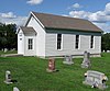 | 1993 ID-Nr. 93000940 | MO A, rund 4 km nordöstlich von Hartsburg 38° 42′ 33″ N, 92° 17′ 6″ W38.709167-92.285 | Hartsburg | |
| 3 | John W. Boone House | 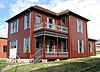 | 1980 ID-Nr. 80002309 | 4th Street zwischen East Broadway und Walnut Street 38° 57′ 8″ N, 92° 19′ 57″ W38.952222-92.3325 | Columbia | |
| 4 | Central Dairy Building |  | 2005 ID-Nr. 04001519 | 1104-1106 East Broadway 38° 57′ 12″ N, 92° 19′ 30″ W38.953333-92.325 | Columbia | |
| 5 | Albert Bishop Chance House and Gardens | 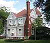 | 1979 ID-Nr. 79001345 | 319 East Sneed Street 39° 12′ 36″ N, 92° 8′ 4″ W39.21-92.134444 | Centralia | |
| 6 | Chatol | 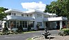 | 1979 ID-Nr. 79001346 | 543 South Jefferson Street 39° 12′ 17″ N, 92° 8′ 6″ W39.204722-92.135 | Centralia | |
| 7 | Coca-Cola Bottling Company Building |  | 2006 ID-Nr. 06000043 | 10 Hitt Street 38° 57′ 3″ N, 92° 19′ 30″ W38.950833-92.325 | Columbia | |
| 8 | Columbia Cemetery |  | 2007 ID-Nr. 06001335 | 30 East Broadway 38° 56′ 56″ N, 92° 20′ 13″ W38.948889-92.336944 | Columbia | |
| 9 | Columbia National Guard Armory |  | 1993 ID-Nr. 93000197 | 701 East Ash Street 38° 57′ 14″ N, 92° 19′ 45″ W38.953889-92.329167 | Columbia | |
| 10 | Sanford F. Conley House | 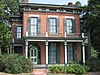 | 1973 ID-Nr. 73001035 | 602 Sanford Pl. 38° 56′ 39″ N, 92° 19′ 52″ W38.944167-92.331111 | Columbia | |
| 11 | Fred Douglass School |  | 1980 ID-Nr. 80002310 | 310 North Providence Road 38° 57′ 18″ N, 92° 19′ 59″ W38.955-92.333056 | Columbia | |
| 12 | Downtown Columbia Historic District | 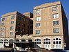 | 2006 ID-Nr. 06000990 | Verschiedene Gebäude in der 7th Street, 8th Street, 9th Street, 10th Street, East Broadway, Cherry Street, Hitt Street, Locust Street und East Walnut Street 38° 57′ 9″ N, 92° 19′ 35″ W38.9525-92.326389 | Columbia | Die Gebäude in der East Walnut Street kamen bei der Erweiterung 2008 hinzu |
| 13 | East Campus Neighborhood Historic District |  | 1996 ID-Nr. 96000019 | Abgegrenzt durch Bouchelle Street, College Street, University Street und High Street sowie Teile der Willis Street, Bass Street, Dorsey Street und Anthony Street 38° 56′ 44″ N, 92° 19′ 7″ W38.945556-92.318611 | Columbia | |
| 14 | Samuel H. and Isabel Smith Elkins House |  | 1996 ID-Nr. 96001012 | 315 North 10th Street 38° 57′ 20″ N, 92° 19′ 36″ W38.955556-92.326667 | Columbia | |
| 15 | First Christian Church |  | 1991 ID-Nr. 91001590 | 101 North Tenth Street 38° 57′ 10″ N, 92° 19′ 36″ W38.952778-92.326667 | Columbia | |
| 16 | Francis Quadrangle Historic District |  | 1973 ID-Nr. 73001036 | Abgegrenzt durch Conley Avenue, Elm Street, 6th Street und 9th Street 38° 56′ 46″ N, 92° 19′ 44″ W38.946111-92.328889 | Columbia | |
| 17 | Gordon Tract Archeological Site |  | 1972 ID-Nr. 72000705 | Adresse nicht veröffentlicht | Columbia | |
| 18 | David Gordon House and Collins Log Cabin | 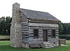 | 1983 ID-Nr. 83000972 | 2100 East Broadway 38° 57′ 0″ N, 92° 18′ 29″ W38.95-92.308056 | Columbia | |
| 19 | Greenwood |  | 1979 ID-Nr. 79001347 | 3005 Mexico Gravel Road 38° 58′ 47″ N, 92° 17′ 32″ W38.979722-92.292222 | Columbia | |
| 20 | David Guitar House |  | 1993 ID-Nr. 93000939 | 2815 Oakland Gravel Road 38° 58′ 47″ N, 92° 18′ 16″ W38.979722-92.304444 | Columbia | |
| 21 | Samuel E. Hackman Building |  | 1998 ID-Nr. 98001501 | 30 South Second Street 38° 41′ 41″ N, 92° 18′ 31″ W38.694722-92.308611 | Hartsburg | |
| 22 | Hamilton-Brown Shoe Factory |  | 2002 ID-Nr. 02000791 | 1123 Wilkes Boulevard 38° 57′ 38″ N, 92° 19′ 22″ W38.960556-92.322778 | Columbia | |
| 23 | William B. Hunt House |  | 1997 ID-Nr. 96001567 | 8939 W. Terrapin Hills Road 38° 55′ 9″ N, 92° 28′ 27″ W38.919167-92.474167 | Columbia | |
| 24 | Kress Building |  | 2005 ID-Nr. 05000122 | 1025 East Broadway 38° 57′ 7″ N, 92° 19′ 32″ W38.951944-92.325556 | Columbia | |
| 25 | Maplewood | 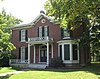 | 1979 ID-Nr. 79001348 | Nifong Boulevard und Ponderosa Drive 38° 54′ 29″ N, 92° 17′ 43″ W38.908056-92.295278 | Columbia | |
| 26 | McCain Furniture Store |  | 2005 ID-Nr. 05000890 | 916 East Walnut Street 38° 57′ 16″ N, 92° 19′ 37″ W38.954444-92.326944 | Columbia | |
| 27 | Eighth and Broadway Historic District |  | 22. Apr. 2003 ID-Nr. 03000298 | 800-810 East Broadway 38° 57′ 4″ N, 92° 19′ 42″ W38.951111-92.328333 | Columbia | Zum Historic District gehören das Miller Building, Matthews Hardware und das Metropolitan Building. |
| 28 | Missouri State Teachers Association Building |  | 1980 ID-Nr. 80002311 | 407 South 6th Street 38° 56′ 48″ N, 92° 19′ 53″ W38.946667-92.331389 | Columbia | |
| 29 | Missouri Theater | 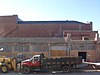 | 1979 ID-Nr. 79001349 | 201-215 South 9th Street 38° 56′ 57″ N, 92° 19′ 39″ W38.949167-92.3275 | Columbia | |
| 30 | Missouri United Methodist Church |  | 1980 ID-Nr. 80002312 | 204 South 9th Street 38° 56′ 57″ N, 92° 19′ 37″ W38.949167-92.326944 | Columbia | |
| 31 | Missouri, Kansas, and Texas Railroad Depot | 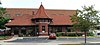 | 1979 ID-Nr. 79001350 | 402 East Broadway 38° 57′ 3″ N, 92° 19′ 56″ W38.950833-92.332222 | Columbia | |
| 32 | North Ninth Street Historic District | 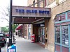 | 2004 ID-Nr. 03001473 | 5-36 North Ninth Street 38° 57′ 7″ N, 92° 19′ 39″ W38.951944-92.3275 | Columbia | |
| 33 | Moses U. Payne House | 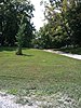 | 1994 ID-Nr. 94001204 | 201 N. Roby Farm Road 38° 57′ 45″ N, 92° 31′ 53″ W38.9625-92.531389 | Rocheport | |
| 34 | Pierce Pennant Motor Hotel |  | 1982 ID-Nr. 82003125 | 1406 Old US 40W 38° 58′ 2″ N, 92° 21′ 32″ W38.967222-92.358889 | Columbia | |
| 35 | Rocheport |  | 1976 ID-Nr. 76001108 | MO 240 38° 58′ 43″ N, 92° 33′ 49″ W38.978611-92.563611 | Rocheport | |
| 36 | St. Paul A.M.E. Church |  | 1980 ID-Nr. 80002315 | 5th Street Ecke Park Street 38° 57′ 17″ N, 92° 19′ 51″ W38.954722-92.330833 | Columbia | |
| 37 | Sanborn Field and Soil Erosion Plots | 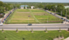 | 1966 ID-Nr. 66000413 | Campus der University of Missouri 38° 56′ 33,2″ N, 92° 19′ 13,8″ W38.942563-92.320488 | Columbia | |
| 38 | Second Baptist Church |  | 1980 ID-Nr. 80002313 | 4th Street Ecke Broadway 38° 57′ 7″ N, 92° 19′ 58″ W38.951944-92.332778 | Columbia | |
| 39 | Second Christian Church |  | 1980 ID-Nr. 80002314 | 401 North 5th Street 38° 57′ 19″ N, 92° 19′ 53″ W38.955278-92.331389 | Columbia | |
| 40 | Senior Hall |  | 1977 ID-Nr. 77000799 | Campus des Stephens College 38° 57′ 1″ N, 92° 19′ 23″ W38.950278-92.323056 | Columbia | |
| 41 | Stephens College South Campus Historic District |  | 2005 ID-Nr. 05001326 | 1200 East Broadway 38° 57′ 9″ N, 92° 19′ 24″ W38.9525-92.323333 | Columbia | |
| 42 | John N. and Elizabeth Taylor House |  | 2001 ID-Nr. 01000546 | 716 West Broadway 38° 57′ 4″ N, 92° 20′ 57″ W38.951111-92.349167 | Columbia | |
| 43 | Tiger Hotel | 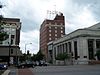 | 1980 ID-Nr. 80002316 | 23 South 8th Street 38° 57′ 2″ N, 92° 19′ 43″ W38.950556-92.328611 | Columbia | |
| 44 | Virginia Building | 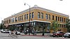 | 2002 ID-Nr. 02000163 | 111 South Ninth Street 38° 57′ 1″ N, 92° 19′ 40″ W38.950278-92.327778 | Columbia | |
| 45 | Wabash Railroad Station and Freight House | 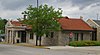 | 1979 ID-Nr. 79001351 | 126 North 10th Street 38° 57′ 12″ N, 92° 19′ 34″ W38.953333-92.326111 | Columbia | |
| 46 | West Broadway Historic District | | 2010 ID-Nr. 10000221 | 300-922 West Broadway 38° 57′ 6″ N, 92° 20′ 50,9″ W38.951669-92.347481 | Columbia | |
| 47 | Wright Brothers Mule Barn | 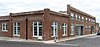 | 2007 ID-Nr. 07001119 | 1101-1107 Hinkson Avenue und 501-507 Fay Street 38° 57′ 26″ N, 92° 19′ 22″ W38.957222-92.322778 | Columbia |
Siehe auch
Einzelnachweise
- ↑ Auszug aus dem National Register of Historic Places – Boone County Abgerufen am 4. Oktober 2012
- ↑ Originals vom 20. Oktober 2012 im Internet Archive) Info: Der Archivlink wurde automatisch eingesetzt und noch nicht geprüft. Bitte prüfe Original- und Archivlink gemäß Anleitung und entferne dann diesen Hinweis.@1@2Vorlage:Webachiv/IABot/www.dnr.mo.gov Abgerufen am 4. Oktober 2012
- ↑ Die Nummerierung in dieser Listenspalte ist an der vom National Park Service vorgelegten Reihenfolge der Einträge orientiert; die Farben unterscheiden verschiedene Schutzgebietstypen des Nationalparksystems mit landesweiter Bedeutung (z. B. National Historic Landmarks) von den sonstigen Einträgen im National Register of Historic Places.
- ↑ National Register Information System. In: National Register of Historic Places. National Park Service, abgerufen am 24. April 2008 (englisch).


Einträge im National Register of Historic Places in Missouri
National Register of Historic Places in Missouri
Adair | Andrew | Atchison | Audrain | Barry | Barton | Bates | Benton | Bollinger | Boone | Buchanan | Butler | Caldwell | Callaway | Camden | Cape Girardeau | Carroll | Carter | Cass | Cedar | Chariton | Christian | Clark | Clay | Clinton | Cole | Cooper | Crawford | Dade | Dallas | Daviess | DeKalb | Dent | Douglas | Dunklin | Franklin | Gasconade | Gentry | Greene | Grundy | Harrison | Henry | Hickory | Holt | Howard | Howell | Iron | Jackson | Jasper | Jefferson | Johnson | Knox | Laclede | Lafayette | Lawrence | Lewis | Lincoln | Linn | Livingston | Macon | Madison | Maries | Marion | McDonald | Mercer | Miller | Mississippi | Moniteau | Monroe | Montgomery | Morgan | New Madrid | Newton | Nodaway | Oregon | Osage | Ozark | Pemiscot | Perry | Pettis | Phelps | Pike | Platte | Polk | Pulaski | Putnam | Ralls | Randolph | Ray | Reynolds | Ripley | Saline | Schuyler | Scotland | Scott | Shannon | Shelby | St. Charles | St. Clair | St. Francois | St. Louis | St. Louis City | Ste. Genevieve | Stoddard | Stone | Sullivan | Taney | Texas | Vernon | Warren | Washington | Wayne | Webster | Worth | Wright


